
Passo del Tonale-east
CyclingUp: Passo del Tonale-east
Climbing effort: 597 cep
Elevation meters: 921
Steepest kilometer: 7.5%
Steepest 250 m: 9%
Foot: 962 m Top: 1883 m
Mean slope: 6.1%
Length: 15.1 km
From: Cusiano
Road conditions (2023): average
Other race bikers: 5-10 per hour
Motor vehicles: 60-180 per hour
Scenery and road:
Restaurant or bar near top: yes
PHOTOS
W SIDE Download gpx
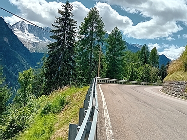
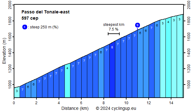
The Passo del Tonale is the highest point of the road connecting the regions of Lombardy, west of the pass, and Trentino-South Tyrol, east of the pass. The road is drawn as a red line in my atlas but the traffic was less heavy than I feared, maybe because I cycled here around midday. However, the trucks, which accounted for a significant portion of the traffic, were unpleasant. This webpage describes the climb to the pass from Cusiano in Trentino. This ascent bridges a difference of 921 meters in altitude and has a simple profile. Over the first 13 kilometers the gradient hardly varies . Of the 26 five hundred meter segments, 17 have a gradient of 7% and 6 a slope of 6%. After these 13 kilometers, there are still two kilometers left, which are less steep (3-4%). As you cycle up there are mighty snow- and ice-covered mountains, belonging to the Presanella group, to the left. The Presanella (3558 m) itself appears short after traversing the village of Vermiglio.
Rijd op 21 maart deze prachtige tocht vanuit Wageningen over de Veluwe. Keuze uit 80 en 125 km met resp. 580 en 990 hoogtemeters. Inschrijving vanaf 31 december
Tour for Life
Rijdt deze zomer de unieke en klassieke 8-daagse wielrentocht van Noord-Italië naar Zuid-Nederland voor Artsen zonder Grenzen!