
Passo Mánghen-south
CyclingUp: Passo Mánghen-south
Climbing effort: 1415 cep
Elevation meters: 1692
Steepest kilometer: 10.5%
Steepest 250 m: 12%
Foot: 355 m Top: 2047 m
Mean slope: 7.4%
Length: 23.0 km
From: Castelnuovo
Road conditions (2021): average
Other race bikers: 5-10 per hour
Motor vehicles: 30-60 per hour
Scenery and road:
Restaurant or bar near top: yes
PHOTOS
N SIDE Download gpx
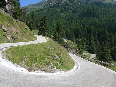

Almost only tourists drove on the road to the Passo Mánghen, even quite a lot, on the beautiful summer day when I cycled from the Valsugana to this pass. The terrace just behind the pass, on the north side, was even crowded. In addition to cars and motorcycles, there were also many cyclists on the road, although the climb is not an easy task. No less than 1692 meters of altitude are waiting for the cyclist and the last 6.5 kilometers are difficult with an average gradient of 9.9% but fortunately without outliers with much higher values. This last part is also the nicest part of the ride. The mountains are rugged and deserted while the road is narrow with a dozen hairpin turns. The 16.5 kilometers before this final section are easier (average 6.4%), but still contain some quite steep passages. The hardest of these lies in the village of Calamento, after 12-13 km cycling, with two 500 meter segments of 12 and 11%, respectively.
Rijd op 29 augustus deze prachtige klimtocht vanuit Wageningen over de Veluwe, door Montferland, Reichswald en Rijk van Nijmegen. Keuze uit 105 en 155 km met resp. 800 en 1180 hoogtemeters. Inschrijving vanaf nu
Tour for Life
Rijdt deze zomer de unieke en klassieke 8-daagse wielrentocht van Noord-Italië naar Zuid-Nederland voor Artsen zonder Grenzen!