
Matschertal
CyclingUp: Matschertal
Climbing effort: 713 cep
Elevation meters: 842
Steepest kilometer: 12.8%
Steepest 250 m: 14%
Foot: 1020 m Top: 1824 m
Mean slope: 5.9%
Length: 13.6 km
From: Tartsch
Road conditions (2015): moderate
Other race bikers: 1-5 per hour
Motor vehicles: 10-30 per hour
Scenery and road:
Restaurant or bar near top: yes
PHOTOS Download gpx

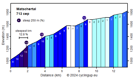
If you like to escape from the bustle of the Vinschgau, I recommend you to bike into the Matschertal (Val di Mazia in Italian), which has hardly been discovered by tourists. The climb begins where the road to Matsch branches off from the main road through the Vinschgau, near Tartsch. The first two kilometers are really steep (9-13%), with a steepest interval of one kilometer of 12.8%, but having finished this part, the worst is already over. There is ample opportunity to enjoy the view of the valley (Vinschgau) and the mountains west of it. The next 4.5 kilometers to Matsch the slope varies between 3 and 10%. The last one and a half kilometers before Matsch are the hardest (9% on average). From Matsch you should follow the signs "Glieshof". There is a quick alternation of easy and steep sections. The steep ones are too short to really hurt. Here it is really nice in the secluded valley with mountains all around. The ride ends at the Glieshof. Note the poor road surface during the descent, as well as the Ortler (3905 m), which now lies ahead.
Rijd op 21 maart deze prachtige tocht vanuit Wageningen over de Veluwe. Keuze uit 80 en 125 km met resp. 580 en 990 hoogtemeters. Inschrijving vanaf 31 december
Tour for Life
Rijdt deze zomer de unieke en klassieke 8-daagse wielrentocht van Noord-Italië naar Zuid-Nederland voor Artsen zonder Grenzen!