
Martelltal
CyclingUp: Martelltal
Climbing effort: 1173 cep
Elevation meters: 1464
Steepest kilometer: 12.5%
Steepest 250 m: 15%
Foot: 661 m Top: 2068 m
Mean slope: 6.2%
Length: 22.7 km
From: Goldrain
Road conditions (2015): good
Other race bikers: 5-10 per hour
Motor vehicles: 30-60 per hour
Scenery and road:
Restaurant or bar near top: yes
PHOTOS VIDEO Download gpx
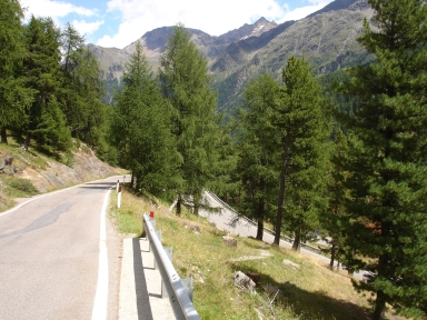

This long climb (23 km) through the Martelltal (Val Martello in Italian) is very suitable for cyclists. Until Gand, which is reached after 10 kilometers, the valley is fairly densely populated, but from there the road is quiet and rather narrow. There are no settlements and the road runs along a beautiful creek (Plimbach) and a reservoir (Zufrittsee). Towards the end one sees the Zufallspitze (3757 m) and the Zufallferner. The slope is quite variable. After the start in Goldrain the slope increases in the course of three kilometers from 2 to 7%. The following section is the most difficult one of the entire ride. First, where the road runs more or less straight for one and a half kilometers, the gradient goes up to 10-11%. Then come two kilometers, where the road zigzags upward, that are less steep (8%). After a short descent (20 elevation meters) climbing continues. Over a longer distance the slope varies widely (1-10%for the intervals of 500 meter). Shortly before the dam there is a very nice and short steep section (up to 11%). Once the dam is reached, three easy kilometers follow, in which one can prepare for another steep section forming the final part of the ascent, with a steepest kilometer of 12.5% and 15% during 250 meters. The ride ends where the asphalt stops.
Rijd op 21 maart deze prachtige tocht vanuit Wageningen over de Veluwe. Keuze uit 80 en 125 km met resp. 580 en 990 hoogtemeters. Inschrijving vanaf 31 december
Tour for Life
Rijdt deze zomer de unieke en klassieke 8-daagse wielrentocht van Noord-Italië naar Zuid-Nederland voor Artsen zonder Grenzen!