
Valmeinier
CyclingUp: Valmeinier
Climbing effort: 824 cep
Elevation meters: 1153
Steepest kilometer: 8.8%
Steepest 250 m: 10%
Foot: 715 m Top: 1855 m
Mean slope: 6.7%
Length: 16.9 km
From: St-Michel-de-Maurienne
Road conditions (2018): good
Other race bikers: 0-1 per hour
Motor vehicles: 10-30 per hour
Scenery and road:
Restaurant or bar near top: no
PHOTOS Download gpx

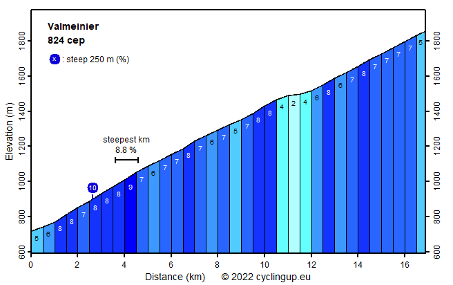
The climb to the ski resort Valmeinier is much less known than the climb to the Col du Télégraphe, while both ascents coincide in their first parts. The route to the ski resort seems to be ignored by cyclists - I didn't see any - but also, albeit to a lesser extent, by car drivers. The ride begins at the bridge over the Arc in St-Michel-de-Maurienne. For the first nine kilometers the road to the Télégraphe is followed. Halfway this part the steepest kilometer of the whole ascent (8.8%) is found. At the end of those nine kilometers, turn left towards Valmeinier. When two kilometers further ahead the first buildings of the ski resort are reached, we leave the forest for the first time so the surrounding mountains become clearly visible. After an easy section, which includes a short descent (11 elevation meters), and the crossing of a stream, we follow the signs to Valmeinier 1800, our goal. Now the road gets steeper again (approx. 7%). When entering Valmeinier 1800 you should turn right and then keep climbing up to the highest point along the edge of the resort. There is a total of 1153 elevation meters in this ascent.
Rijd op 21 maart deze prachtige tocht vanuit Wageningen over de Veluwe. Keuze uit 80 en 125 km met resp. 580 en 990 hoogtemeters. Inschrijving vanaf 31 december
Tour for Life
Rijdt deze zomer de unieke en klassieke 8-daagse wielrentocht van Noord-Italië naar Zuid-Nederland voor Artsen zonder Grenzen!