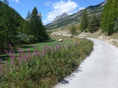
Vallée du Cristillan

CyclingUp: Vallée du Cristillan

Climbing effort: 719 cep
Elevation meters: 956
Steepest kilometer: 10.5%
Steepest 250 m: 13%
Foot: 1057 m Top: 2009 m
Mean slope: 6.4%
Length: 14.8 km
From: Maison du Roi
Road conditions (2020): moderate
Other race bikers: 1-5 per hour
Motor vehicles: <10 per hour
Scenery and road:
Restaurant or bar near top: no
PHOTOS Download gpx

The climb through the Vallée du Cristillan is very beautiful, especially the last part of the ascent, which starts at the turnoff into the Vallée de Mélezet. Mountains, a stream and tranquillity characterize this part of the climb. The turnoff to the Vallée de Mélezet is reached after eight kilometers of cycling, near Ceillac. Continue from there for about a kilometer on the D260, leaving Ceillac on your right-hand side and l'Ochette on your left-hand side. Then head into a narrow valley (Vallée du Cristillan) and you will have to climb a steep ramp, which includes a 250 meter segment of 13%. After that, the road, which is often of poor quality, gets less steep and this doesn't change anymore on the remaining five kilometers (4-7%). The finish lies at the end of the asphalt at an altitude of 2009 meters. The part of the climb described here above is preceded by a ride on the D60, starting in the valley of the Guil and ending at the turnoff mentioned above. In this first part the first six kilometers are quite steep (mostly 8-9%).


Rijd op 22 maart deze prachtige tocht over de Veluwe, 75 of 125 kilometer vanuit Wageningen. Met veel hoogtemeters: resp. 550 en 970. Inschrijving
1K Ride
Rijd op 15 juni deze tocht met meer dan 1000 hoogtemeters; 80, 120 of 145 kilometer vanuit Oosterbeek. Inschrijving
Tour for Life
Rijdt deze zomer de unieke en klassieke 8-daagse wielrentocht van Noord-Italië naar Zuid-Nederland voor Artsen zonder Grenzen!

