
Val Thorens-north
CyclingUp: Val Thorens-north
Climbing effort: 1312 cep
Elevation meters: 1878
Steepest kilometer: 9.5%
Steepest 250 m: 10%
Foot: 520 m Top: 2318 m
Mean slope: 5.6%
Length: 31.8 km
From: Salins les Thermes
Road conditions (2022): average
Other race bikers: 10-25 per hour
Motor vehicles: 10-30 per hour
Scenery and road:
Restaurant or bar near top: yes
PHOTOS
NW SIDE Download gpx
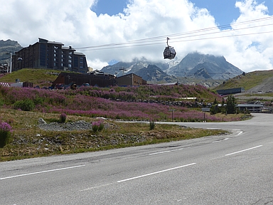
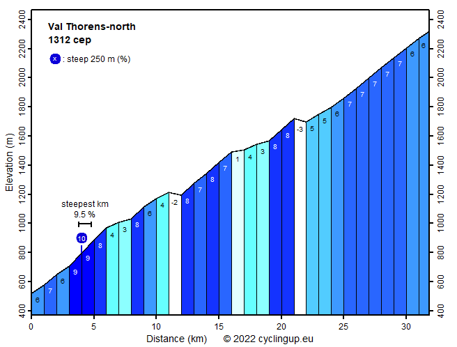
In its second half this climb to Val Thorens runs through Les Trois Vallées, the largest ski area in the world with 600 kilometers of pistes. There are no less than 156 ski lifts (in 2022). If you cycle here in summer, you can see some of these lifts, plus the accommodations for guests in among others Saint-Martin-de-Belleville, Les Menuires and, at the end of the road, Val Thorens. Therefore, the surroundings are not really nice, the street is wide and busy, though fortunately a little quieter after les Menuires. For the first part of the ride, ending at 1193 meters of altitude, the cyclist can choose between two more or less parallel running options. The climb of this page, the easterly option via St-Laurens de la Côte, seems to me to have only advantages relative to the alternative option via St-Jean-de-Belleville, which runs further to the west. The road is narrower, much quieter and better paved (in 2022). In addition, the route via St-Laurens offers more shade in the morning. Both variants are almost equally hard (1312 versus 1292 climb effort points or cep, respectively, for the eastern or the western option. The whole climb is long (nearly 32 kilometers) and bridges many meters of altitude (1798) Of these, 80 have to be climbed twice because there are several downhill sections along the way. It doesn't get really steep anywhere. The steepest kilometer (9.5%) lies at about 4 kilometers after the start.
Rijd op 22 maart deze prachtige tocht over de Veluwe, 75 of 125 kilometer vanuit Wageningen. Met veel hoogtemeters: resp. 550 en 970. Inschrijving
1K Ride
Rijd op 15 juni deze tocht met meer dan 1000 hoogtemeters; 80, 120 of 145 kilometer vanuit Oosterbeek. Inschrijving
Tour for Life
Rijdt deze zomer de unieke en klassieke 8-daagse wielrentocht van Noord-Italië naar Zuid-Nederland voor Artsen zonder Grenzen!