
Pralognan-Les Prioux
CyclingUp: Pralognan-Les Prioux
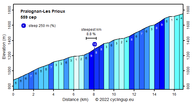
Climbing effort: 559 cep
Elevation meters: 877
Steepest kilometer: 8.8%
Steepest 250 m: 10%
Foot: 880 m Top: 1755 m
Mean slope: 5.2%
Length: 16.9 km
From: le_Villard_de_Planay
Road conditions (2012): average
Other race bikers: 1-5 per hour
Motor vehicles: 10-30 per hour
Scenery and road:
Restaurant or bar near top: yes
PHOTOS Download gpx

This climb follows a valley road in the Vanoise. It starts from the village of le Villard de Planay with some hairpin turns and a moderately steep slope (around 7%). The rest of the climb consists of three steeper parts (up to 9%) with easier phases in between. The end is at a car park near Les Prioux where in summer an amazingly large number of cars belonging to tourists hiking from Les Prioux into the mountains may be gathered. Though the road between Villard de Planay and Pralognan is marked as a "Route principale" on my road map, traffic is of a reasonable density. Traffic after Pralognan is light anyway. The most beautiful view is on the descent from Les Prioux to Pralognan when several peaks among which the Pointe de la Grande Casse decorate the background.
Rijd op 21 maart deze prachtige tocht vanuit Wageningen over de Veluwe. Keuze uit 80 en 125 km met resp. 580 en 990 hoogtemeters. Inschrijving vanaf 31 december
Tour for Life
Rijdt deze zomer de unieke en klassieke 8-daagse wielrentocht van Noord-Italië naar Zuid-Nederland voor Artsen zonder Grenzen!