Feissons-sur-Salins-west

CyclingUp: Feissons-sur-Salins-west

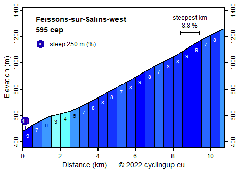
Climbing effort: 595 cep
Elevation meters: 783
Steepest kilometer: 8.8%
Steepest 250 m: 11%
Foot: 480 m Top: 1263 m
Mean slope: 7.3%
Length: 10.8 km
From: Moûtiers
Road conditions (2022): average
Other race bikers: 1-5 per hour
Motor vehicles: 10-30 per hour
Scenery and road:
Restaurant or bar near top: no
PHOTOS
E SIDE Download gpx

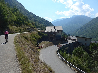
Feissons-sur-Salins is located on the northern side of the Vallée de Bozel. Here you are away from the hustle and bustle around Moûtiers and from the Les Trois Vallées ski area, located on the other side of the Vallée de Bozel. Feissons is at the end of a cul-de-sac. After starting the ride in Moûtiers, the road is immediately very steep with a section of 250 meters of 11%, to level off soon. After that it gets steeper again. From kilometers 3 after the start to the end of the ride (a distance of 8 kilometers) the slope varies little (7-9%). On a sunny day, the last kilometers can be hard because there is little shade. The ascent covers a total of 783 meters in altitude.


Camping Les Erables .
Tip!
Ideal starting point for Col du Grand Colombier and Col de la Biche.
Warm hospitality and swimming pool nearby.
Veluviatocht
Rijd op 22 maart deze prachtige tocht over de Veluwe, 75 of 125 kilometer vanuit Wageningen. Met veel hoogtemeters: resp. 550 en 970. Inschrijving
1K Ride
Rijd op 15 juni deze tocht met meer dan 1000 hoogtemeters; 80, 120 of 145 kilometer vanuit Oosterbeek. Inschrijving
Tour for Life
Rijdt deze zomer de unieke en klassieke 8-daagse wielrentocht van Noord-Italië naar Zuid-Nederland voor Artsen zonder Grenzen!

