
Côte de Montgirod-Hautecour-northeast
CyclingUp: Côte de Montgirod-Hautecour-northeast
Climbing effort: 448 cep
Elevation meters: 617
Steepest kilometer: 8.4%
Steepest 250 m: 9%
Foot: 650 m Top: 1250 m
Mean slope: 6.0%
Length: 9.9 km
From: Centron
Road conditions (2022): average
Other race bikers: 0-1 per hour
Motor vehicles: 10-30 per hour
Scenery and road:
Restaurant or bar near top: no
PHOTOS
SW SIDE Download gpx

The most direct road connection between Aime and Moûtiers
is the N90 through the valley of the Isère
but for cyclists this road is dangerous.
Many parts of the road are bordered by a cycle lane
but the lane is mostly narrow, and cars and motorcycles drive fast.
It is noteworthy though that the Tunnel de Siaix,
which constitutes a part of the N90 here,
is not an insurmountable obstacle
because separated from the road a
"galérie de securité"
has been built, which can be used by cyclists.
For those who tend to like cycling upwards,
two alternatives exist, one on the orographic
left bank of the Isère (the D88 via the
Col du Tra)
and one on the orographic
right bank of the Isère (the D85 and the D85b across the
Côte de Montgirod-Hautecour, described here).
These are quiet or very quiet routes,
the roads are not wide and sometimes even very narrow,
and generally have many bends and hairpin bends.
In short, these alternatives are great for road cyclists.
The number of elevation meters of the four climbs varies
between 617 and 775.
Coming from Aime
the ascent to the Côte de Montgirod-Hautecour begins
at the exit of the N90 to Montgirod.
After an almost horizontal first kilometer,
in the next six kilometers the cyclist climbs
with eight hairpin bends to the village of Montgirod.
There is little forest here, so you sweat badly
when the sun is shining.
The slope is almost always 7 or 8%.
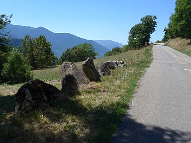
The last 3 kilometers of the ride are really beautiful.
They start in Montgirod and run on a three meter wide road
where I met only one car.
Watch out for water drains across the street!
The culmination point is not signposted.
Rijd op 29 augustus deze prachtige klimtocht vanuit Wageningen over de Veluwe, door Montferland, Reichswald en Rijk van Nijmegen. Keuze uit 105 en 155 km met resp. 800 en 1180 hoogtemeters. Inschrijving vanaf nu
Tour for Life
Rijdt deze zomer de unieke en klassieke 8-daagse wielrentocht van Noord-Italië naar Zuid-Nederland voor Artsen zonder Grenzen!