
Col de la Madeleine-southwest
CyclingUp: Col de la Madeleine-southwest
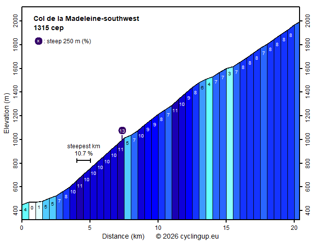
Climbing effort: 1315 cep
Elevation meters: 1546
Steepest kilometer: 10.7%
Steepest 250 m: 13%
Foot: 450 m Top: 1993 m
Mean slope: 7.6%
Length: 20.4 km
From: La_Chambre
Road conditions (2025): average
Other race bikers: 10-25 per hour
Motor vehicles: 10-30 per hour
Scenery and road:
Restaurant or bar near top: yes
PHOTOS
S N SIDE Download gpx

From the Arc valley there are two ways
to ride up to the Col de la Madeleine:
either via the D213 (the
southern ascent to the Col de la Madeleine)
or via Montgellafrey taking the D76.
The latter climb joins the D213 in Saint-François-Longchamp,
from where both approaches share the final 5 kilometres.
The variant via Montgellafrey is described here
and is clearly my preferred option.
The road is narrower and there is much less traffic
than in the other option.
A delight for real climbers is the four-kilometre section
starting at the last houses of Notre-Dame-du-Cruet
(after 3.5 kilometres of cycling)
and ending just before Montgellafrey.
In this section 410 metres of elevation are gained,
corresponding to an average gradient of 10.3%.
After that, there are still 8 kilometres to go
before reaching the D213 in Saint-François-Longchamp,
in which the gradient varies greatly
(3–11% with an average of 7.5%).
Most of the time the road runs through forest,
so there are hardly any views.
This changes on the final 5 kilometres along the D213 to the pass.
Here the landscape is open and offers wide views.
From a sporting standpoint, however,
this section is somewhat monotonous,
as the gradient is almost constantly 8%.
Once the climb is completed,
one can relax on a terrace at the top.
That is well deserved,
because this ascent is
almost as demanding as the hardest variants of Mont Ventoux.
This route is also regularly used by the Tour de France.
I was here on a day in 2025
when a stage of the Tour de France Femmes
finished with this climb to the Madeleine.
Before the race, an organised road cycling tour took place.
Many of my photos show participants in this tour.
Rijd op 21 maart deze prachtige tocht vanuit Wageningen over de Veluwe. Keuze uit 80 en 125 km met resp. 580 en 990 hoogtemeters. Inschrijving vanaf 31 december
Tour for Life
Rijdt deze zomer de unieke en klassieke 8-daagse wielrentocht van Noord-Italië naar Zuid-Nederland voor Artsen zonder Grenzen!