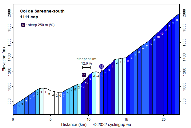
Col de Sarenne-south

CyclingUp: Col de Sarenne-south

Climbing effort: 1111 cep
Elevation meters: 1354
Steepest kilometer: 12.6%
Steepest 250 m: 14%
Foot: 743 m Top: 1999 m
Mean slope: 5.7%
Length: 22.1 km
From: Le Clapier
Road conditions (2015): moderate
Other race bikers: >25 per hour
Motor vehicles: <10 per hour
Scenery and road:
Restaurant or bar near top: no
PHOTOS VIDEO Download gpx

What a fantastic ascent! In the last seven kilometers, from Clavan-le-Haut, there are stunning views, the road is narrow and steep and there is practically no traffic. The only downside of this part of the climb is the large amount of gravel on the asphalt. The route starts in Le Clapier, from where it runs nine kilometers on the D1091 in the direction of Briançon. This includes a descent of 65 elevation meters but net 300 elevation meters are gained. After taking the side road to Mizoën, climbing becomes serious with a one and a half kilometer section of 9-12%. This section is followed by a descent of 30 meters, a steeper part (up to 11%) and then again an easy passage. So far the road is excellent. Then, at Clavan-le-Haut the nicest part begins. First, the road is moderately steep (mostly 7-8%) and heads northward. After Le Perron the road winds upward with several hairpin bends, now taking a westerly and later a south-westerly direction towards the pass. This allows better views of the giants of the Écrins (especially La Meije, 3983 meters, and the Roche de la Muzelle, 3564 meters) which first lay behind the cyclist but are now more or less ahead. This part is pretty steep, 8-10% according to the profile, but at a small scale there are steeper passages. The col has the remarkable altitude of 1999 meters.


Rijd op 30 augustus deze prachtige klimtocht vanuit Wageningen over de Veluwe, door Montferland, Reichswald en Rijk van Nijmegen. Keuze uit 105 en 155 km met resp. 750 en 1130 hoogtemeters. Inschrijven vanaf 22 juni
Tour for Life
Rijdt deze zomer de unieke en klassieke 8-daagse wielrentocht van Noord-Italië naar Zuid-Nederland voor Artsen zonder Grenzen!

