
Col de Plan du Lac
CyclingUp: Col de Plan du Lac
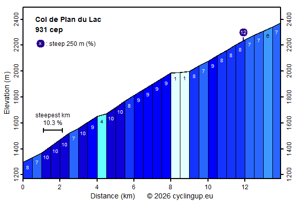
Climbing effort: 931 cep
Elevation meters: 1093
Steepest kilometer: 10.3%
Steepest 250 m: 12%
Foot: 1294 m Top: 2370 m
Mean slope: 7.7%
Length: 13.9 km
From: Termignon
Road conditions (2025): average
Other race bikers: 1-5 per hour
Motor vehicles: 10-30 per hour
Scenery and road:
Restaurant or bar near top: no
PHOTOS Download gpx

This climb starts in Termignon and
takes the cyclist up to the Col de Plan du Lac (2370 metres),
located in the core zone of the Vanoise National Park.
This core zone is reached roughly at the tree line,
at around 2000 metres above sea level.
While the route is already beautiful below that line,
the landscape becomes much more impressive above the tree line.
Looking westwards, snow- and ice-covered peaks can be seen in the distance
while the road itself runs through nearby mountains
with a yellowish-coloured type of rock
that I had not encountered elsewhere in this region (limestone?).
The landscape looks dry here;
one could easily imagine being
in an area around the Mediterranean.
From the pass there are views to the north
of the Grande Casse (3855 metres)
and, more nearby, of two small lakes.
The first 8 kilometres are the hardest of the entire climb.
Here gradients of 9 and 10% dominate the profile.
This beginning is followed by an easier kilometre (1%),
where one can briefly recover.
After that, there are still 5 kilometres to go —
the most beautiful part of the ride,
as already mentioned above.
These final kilometres are slightly easier
(mostly 7–8%)
than the first 8 kilometres of the ascent.
Rijd op 21 maart deze prachtige tocht vanuit Wageningen over de Veluwe. Keuze uit 80 en 125 km met resp. 580 en 990 hoogtemeters. Inschrijving vanaf 31 december
Tour for Life
Rijdt deze zomer de unieke en klassieke 8-daagse wielrentocht van Noord-Italië naar Zuid-Nederland voor Artsen zonder Grenzen!