
Col de Montgenèvre-west
CyclingUp: Col de Montgenèvre-west
Climbing effort: 362 cep
Elevation meters: 598
Steepest kilometer: 7.6%
Steepest 250 m: 9%
Foot: 1260 m Top: 1850 m
Mean slope: 4.7%
Length: 12.5 km
From: Briançon
Road conditions (2016): good
Other race bikers: >25 per hour
Motor vehicles: >180 per hour
Scenery and road:
Restaurant or bar near top: yes
PHOTOS Download gpx
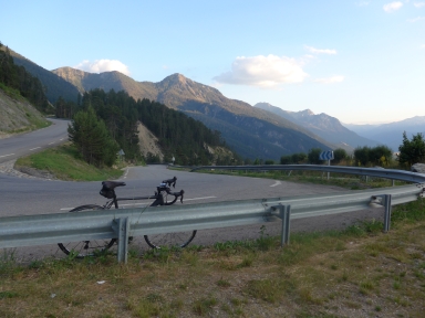
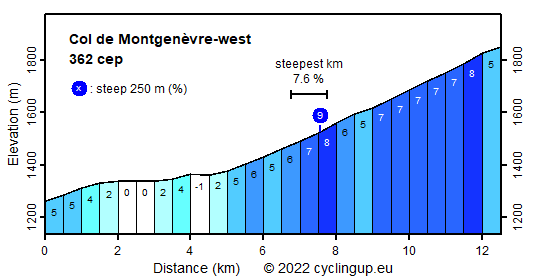
Although I have seen many race bikers here, I would not really recommend this climb. The road is wide and busy and the scenery is not that impressive. However, there is a nice view of Briançon with its fortifications built in the seventeenth century to guard the road to Italy. Also, half way there is a nice view in northerly direction along the Vallée de la Clarée and of the surrounding mountains. The ride begins at the junction of the N94 and the D994F in Briançon and then, over the first two kilometers, the route leads gently sloping (4-5%) through the city. The following three kilometers bring only little gain of elevation (0-4%), but after that the real climb begins. The remaining seven kilometers are moderately steep (about 7%). The steepest kilometer has a slope of 7.6%. At a roundaout in the ski resort of Montgenèvre, located on the border of France and Italy, cyclists are not allowed to continue straight because of a tunnel. Take the road that lies left of and parallel to the tunnel to reach the pass one kilometer further ahead.
Rijd op 21 maart deze prachtige tocht vanuit Wageningen over de Veluwe. Keuze uit 80 en 125 km met resp. 580 en 990 hoogtemeters. Inschrijving vanaf 31 december
Tour for Life
Rijdt deze zomer de unieke en klassieke 8-daagse wielrentocht van Noord-Italië naar Zuid-Nederland voor Artsen zonder Grenzen!