
Col de Carri-north
CyclingUp: Col de Carri-north
Climbing effort: 701 cep
Elevation meters: 1058
Steepest kilometer: 10.3%
Steepest 250 m: 11%
Foot: 314 m Top: 1202 m
Mean slope: 3.6%
Length: 24.9 km
From: St-Laurent-en-Royans
Road conditions (2020): average
Other race bikers: 5-10 per hour
Motor vehicles: 30-60 per hour
Scenery and road:
Restaurant or bar near top: no
PHOTOS Download gpx
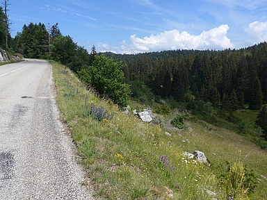

This actually is a combination of the ascent to the Col de la Machine from St-Laurent-en-Royans and the continuation to the Col de Carri. Depending on your mood, the first part can be replaced by the parallel climb from St-Jean-en-Royans to the Col de la Machine, which on this website forms the first part of an ascent to the Col de Chaud Clapier. I was a little disappointed by this trip. The road, especially up to the Col de la Machine, is quiet but broad and virtually without a view of the lots of fantastic, steep and colored rock faces of the Vercors. During the first 11.5 kilometers from St-Laurent, 772 elevation meters are climbed, on a road that leads continuously upward, but with a strongly varying slope. The steepest kilometer (10.3%) begins about four kilometers after the start. After these first 11.5 kilometers of climbing, there is an alternation of up- and down-going sections until the Col de la Machine, which, strangely enough, is not a pass at all for cyclists. The remaining seven kilometers to the Col de Carri run through the forest and are definitely not steep (maximum 5%).
Rijd op 21 maart deze prachtige tocht vanuit Wageningen over de Veluwe. Keuze uit 80 en 125 km met resp. 580 en 990 hoogtemeters. Inschrijving vanaf 31 december
Tour for Life
Rijdt deze zomer de unieke en klassieke 8-daagse wielrentocht van Noord-Italië naar Zuid-Nederland voor Artsen zonder Grenzen!