HOME cyclingup.eu

regions

method
contact
links
French Alps
Switzerland
Austria
Italian Alps
French Pyrenees
Spain
Gran Canaria
Vosges
Black Forest
Brocken, Germany
Ardennes
Netherlands
Col d'Allos-north
CyclingUp: Col d'Allos-north
Climbing effort: 760 cep
Elevation meters: 1109
Steepest kilometer: 8.1%
Steepest 250 m: 10%
Foot: 1138 m Top: 2247 m
Mean slope: 6.5%
Length: 16.9 km
From: Barcelonnette
Road conditions (2013): average
Other race bikers: 5-10 per hour
Motor vehicles: 10-30 per hour
Scenery and road:
Restaurant or bar near top: no
PHOTOS Download gpx
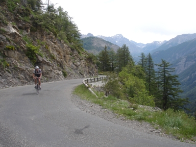
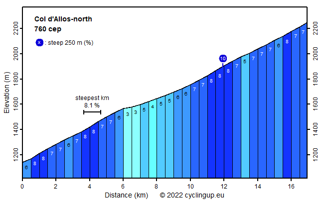
This is a rather long, very smooth climb, relatively easy with the steepest kilometer having a slope of 8%. It is perfectly suitable for race bikers. The road is relatively small with little traffic, offers nice though not exciting scenery and fair road conditions. My profile starts where the road to the Col de la Cayolle splits from the route to the Col d'Allos, ~2 km from Barcelonnette. Immediately, the slope is 7-8%, which is typical for the entire tour. The most noticeable exception is the part beginning after 6 km, just before Les Agneliers, which is less steep (3-5%). A few kilometers after Les Angeliers a view opens on the route to the Col de la Cayolle-north with the Cime de la Bonette in the background.
Camping Les Erables .
Tip!
Ideal starting point for Col du Grand Colombier and Col de la Biche.
Warm hospitality and swimming pool nearby.
Veluviatocht
Rijd op 21 maart deze prachtige tocht vanuit Wageningen over de Veluwe. Keuze uit 80 en 125 km met resp. 580 en 990 hoogtemeters. Inschrijving vanaf 31 december
Tour for Life
Rijdt deze zomer de unieke en klassieke 8-daagse wielrentocht van Noord-Italië naar Zuid-Nederland voor Artsen zonder Grenzen!