
Chalets de Laval
CyclingUp: Chalets de Laval
Climbing effort: 286 cep
Elevation meters: 445
Steepest kilometer: 8.7%
Steepest 250 m: 10%
Foot: 1590 m Top: 2020 m
Mean slope: 4.5%
Length: 9.6 km
From: Névache
Road conditions (2016): average
Other race bikers: 10-25 per hour
Motor vehicles: 30-60 per hour
Scenery and road:
Restaurant or bar near top: no
PHOTOS Download gpx
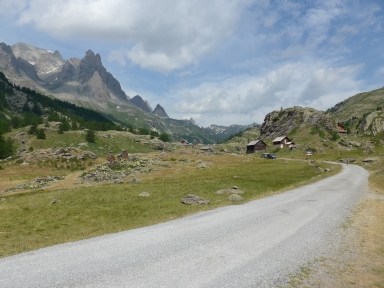
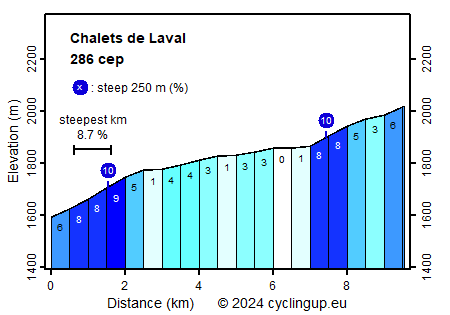
From the Vallée de la Clarée one can make two climbs. The first leads from the junction of the road through the valley and the D1t to the col de l'Ëchelle. This one has only 179 elevation meters. More interesting is the climb to Chalets de Laval from Névache. Again, this is not a tough ascent but it is well worth the effort because of the splendid mountains and the narrow road with relatively little traffic. Many cyclists have discovered this nice climb. The ride starts at the junction just east of Névache. Keep here right in the direction Haute Vallée. The first slightly more than two kilometers are the hardest part of the ascent (5-9%). The remaining seven kilometers, the road mostly runs through a forest where the trees are far apart so one can fully enjoy the beautiful mountains, the forest and the stream. In addition, during some five kilometers the road hardly climbs up (maximum 4%) and only in the final two and a half kilometers some climb effort has to be made again (3-8%). Unfortunately there were many horseflies on the day I cycled here.
Rijd op 21 maart deze prachtige tocht vanuit Wageningen over de Veluwe. Keuze uit 80 en 125 km met resp. 580 en 990 hoogtemeters. Inschrijving vanaf 31 december
Tour for Life
Rijdt deze zomer de unieke en klassieke 8-daagse wielrentocht van Noord-Italië naar Zuid-Nederland voor Artsen zonder Grenzen!