
Sohlberg-west
CyclingUp: Sohlberg-west
Climbing effort: 478 cep
Elevation meters: 466
Steepest kilometer: 12.2%
Steepest 250 m: 14%
Foot: 219 m Top: 685 m
Mean slope: 9.5%
Length: 4.9 km
From: Lautenbach
Road conditions (2016): moderate
Other race bikers: 0-1 per hour
Motor vehicles: <10 per hour
Scenery and road:
Restaurant or bar near top: no
PHOTOS
N SIDE Download gpx

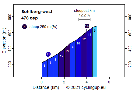
The climb from Lautenbach to Sohlberg is one of the most beautiful in the Black Forest. The quiet, narrow street winds itself up through a steep, beautiful valley with meadows, fields and forests. Early May the meadows are full with dandelions and flowering fruit trees. This ride is a great joy for the true climber. The road is mostly steep (at least 8%) and there are two sections where cyclists are truely tortured (up to 13% for the 500 meter sections). The route is easy to find except when reaching the ridge of the hill. Here one should turn sharply to the left and continue straight at a junction 100 meters further on. Another 300 meters are still missing to the finish which is located at the place where the tarmac road turns to the right. Pay attention when descending to Lautenbach because the pavement is in a bad condition (2016) .
Rijd op 22 maart deze prachtige tocht over de Veluwe, 75 of 125 kilometer vanuit Wageningen. Met veel hoogtemeters: resp. 550 en 970. Inschrijving
1K Ride
Rijd op 15 juni deze tocht met meer dan 1000 hoogtemeters; 80, 120 of 145 kilometer vanuit Oosterbeek. Inschrijving
Tour for Life
Rijdt deze zomer de unieke en klassieke 8-daagse wielrentocht van Noord-Italië naar Zuid-Nederland voor Artsen zonder Grenzen!