HOME cyclingup.eu

regions

method
contact
links
French Alps
Switzerland
Austria
Italian Alps
French Pyrenees
Spain
Gran Canaria
Vosges
Black Forest
Brocken, Germany
Ardennes
Netherlands
Kreuzweg-west
CyclingUp: Kreuzweg-west
Climbing effort: 496 cep
Elevation meters: 711
Steepest kilometer: 8.1%
Steepest 250 m: 10%
Foot: 360 m Top: 1071 m
Mean slope: 6.6%
Length: 10.7 km
From: Badenweiler
Road conditions (2017): good
Other race bikers: 5-10 per hour
Motor vehicles: 60-180 per hour
Scenery and road:
Restaurant or bar near top: no
PHOTOS
E N SIDE Download gpx

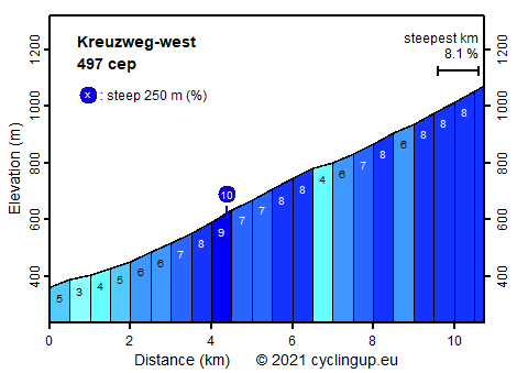
This ascent overcomes a considerable number of elevation meters (711). The ride is perhaps a little boring because the slope does not vary much (mostly 6-8%) and because the forest hardly allows views. Nevertheless, I enjoyed the climb since the valley, through which one bikes up, provided a feeling of loneliness. There is also some variation through three sections with bends, necessary to gain height. From the parking lot at Kreuzweg there is a wonderful view in the east direction, among other things on the Belchen, which is visible from almost everywhere in this region. It is lying on the left side of the road rising far above the rest of the landscape.
Germania klimtocht
Rijd op 29 augustus deze prachtige klimtocht vanuit Wageningen over de Veluwe, door Montferland, Reichswald en Rijk van Nijmegen. Keuze uit 105 en 155 km met resp. 800 en 1180 hoogtemeters. Inschrijving vanaf nu
Tour for Life
Rijdt deze zomer de unieke en klassieke 8-daagse wielrentocht van Noord-Italië naar Zuid-Nederland voor Artsen zonder Grenzen!