
Hohloh-northwest
CyclingUp: Hohloh-northwest
Climbing effort: 576 cep
Elevation meters: 800
Steepest kilometer: 10.7%
Steepest 250 m: 12%
Foot: 184 m Top: 984 m
Mean slope: 6.4%
Length: 12.5 km
From: Hilpertsau
Road conditions (2014): average
Other race bikers: 0-1 per hour
Motor vehicles: 30-60 per hour
Scenery and road:
Restaurant or bar near top: no
PHOTOS Download gpx
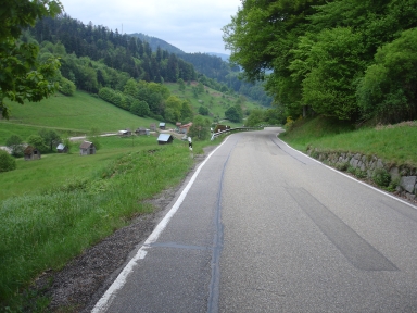
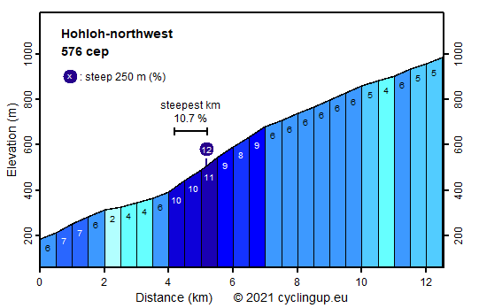
Among the climbs in the northern part of the Black Forest, the tour to the top of the Hohloh is one of the most challenging. The first 4 kilometers until the village of Reichental are moderate to easy with the slope not exceeding 7%. The challenge mainly resides in the 3 kilometers starting in Reichenbach with the slope ranging between 8 and 11%. The remaining 5.5 kilometers are easier again (up to 6%). As to the landscape, much of the tour winds through forests. Around Reichenbach, characterized by typical timber-frame houses, the road follows a beautiful valley with farmlands. During the last few kilometers the forest becomes more open which allows views to the Rhine valley and the Vosges. Also, the finish of the climb, the Kaiser-Wilhelm-Turm (984 m) situated near the summit of Hohloh (988 m) is visible on the right hand side. Many cyclists will regard the col of Schwarzmiss (933 m) as the finish, skipping the final kilometer (50 m; 30 cep).
Rijd op 21 maart deze prachtige tocht vanuit Wageningen over de Veluwe. Keuze uit 80 en 125 km met resp. 580 en 990 hoogtemeters. Inschrijving vanaf 31 december
Tour for Life
Rijdt deze zomer de unieke en klassieke 8-daagse wielrentocht van Noord-Italië naar Zuid-Nederland voor Artsen zonder Grenzen!