
Büchereck-east
CyclingUp: Büchereck-east
Climbing effort: 268 cep
Elevation meters: 336
Steepest kilometer: 9.5%
Steepest 250 m: 12%
Foot: 315 m Top: 651 m
Mean slope: 7.5%
Length: 4.5 km
From: Gutach
Road conditions (2014): excellent
Other race bikers: 0-1 per hour
Motor vehicles: 30-60 per hour
Scenery and road:
Restaurant or bar near top: no
PHOTOS Download gpx
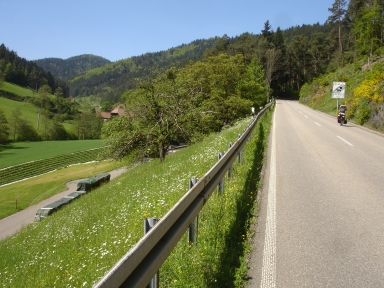
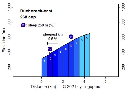
The climb to Büchereck from the Gutachtal is a short, steep climb mainly through forests. The climb starts at the beginning of road L107, south of Gutach. Soon a road sign announces that the slope will be 18% but this is a strong exaggeration. The steepness that I measured over intervals of 250 m does not exceed 12%. After the relatively easy first few hundred meters (7%), the road steepens to approximately 10%. Over the next 3 kilometers the mean slope (8%) is not extreme but since a few parts are definitely steeper, climbing is harder than those 8% suggest. The final kilometer has a more gentle slope (5%). Views are rare with the exception of the first and the final few hundred meters. Road conditions were excellent when I made the climb (2014).
Rijd op 22 maart deze prachtige tocht over de Veluwe, 75 of 125 kilometer vanuit Wageningen. Met veel hoogtemeters: resp. 550 en 970. Inschrijving
1K Ride
Rijd op 15 juni deze tocht met meer dan 1000 hoogtemeters; 80, 120 of 145 kilometer vanuit Oosterbeek. Inschrijving
Tour for Life
Rijdt deze zomer de unieke en klassieke 8-daagse wielrentocht van Noord-Italië naar Zuid-Nederland voor Artsen zonder Grenzen!