
Brandenkopf-west
CyclingUp: Brandenkopf-west
Climbing effort: 657 cep
Elevation meters: 697
Steepest kilometer: 11.3%
Steepest 250 m: 14%
Foot: 250 m Top: 945 m
Mean slope: 8.0%
Length: 8.7 km
From: Unterharmersbach
Road conditions (2016): good
Other race bikers: 1-5 per hour
Motor vehicles: 30-60 per hour
Scenery and road:
Restaurant or bar near top: yes
PHOTOS VIDEO
N E SW SIDE Download gpx

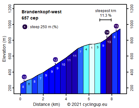
The Brandenkopf is an attractive destination for the true climber. This mountain can be climbed on paved roads from four sides. All variants are steep to very steep. This especially holds for the last one and a half kilometers up to the summit. These start at a crossing named Bettelfrau (beggar woman in English) and is identical for the four ascents. This final ramp contains two extremely steep 250 meter sections (14 and 13%). In addition, the road surface of this part is miserable but as a reward for the effort there is a "Wanderheim" with terrace at the end. The climb from the west, described here, begins in Unterharmersbach. During the first three kilometers the road leads through a landscape with meadows and farms. Here the slope is moderate (6-9%). In the distance the radio mast near the top of the Brandenkopf can be seen. When one enters the forest, the hard work begins on a two and a half kilometer section with a slope of between 9 and 11%. A bifurcation marks the end of this section. From the left comes the north ascent to the Brandenkopf. We take the road to the right and on the following two kilometers to Bettelfrau (1-7%) we may recover somewhat and prepare mentally for the final ramp.
Rijd op 29 augustus deze prachtige klimtocht vanuit Wageningen over de Veluwe, door Montferland, Reichswald en Rijk van Nijmegen. Keuze uit 105 en 155 km met resp. 800 en 1180 hoogtemeters. Inschrijving vanaf nu
Tour for Life
Rijdt deze zomer de unieke en klassieke 8-daagse wielrentocht van Noord-Italië naar Zuid-Nederland voor Artsen zonder Grenzen!