
-west
CyclingUp: -west
Climbing effort: cep
Elevation meters:
Steepest kilometer: %
Steepest 250 m: %
Foot: m Top: m
Mean slope: %
Length: km
From:
Road conditions ():
Other race bikers: per hour
Motor vehicles: per hour
Scenery and road:
Restaurant or bar near top:
PHOTOS VIDEO Download gpx
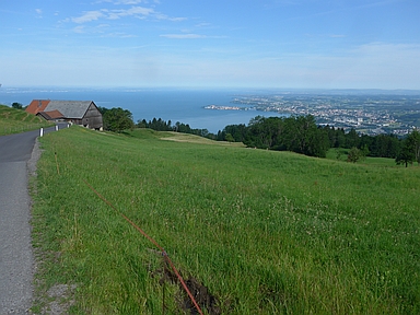
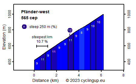
The Pfänder (1064 m) is Bregenz's local mountain, known for the Pfänder tunnel through which the A14 runs. From Lochau, a few kilometers north of Bregenz, two paved routes lead to a crossing (Moosegg, 1004 m) not far from the summit of the Pfänder. The variant described here is the shortest (6.2 kilometers) and hardest (565 climb effort points) of both options. This ride is a good candidate for improving your personal best in cycling up because the slope is almost always 9, 10 or 11%, ideal for quickly gaining altitude. The road is exciting, winding and narrow. In the lower half mainly meadows and buildings surround the road; after that the forest dominates. Views are wide with Lake Constance as the most striking element. A good place to enjoy the views is located near the mountain station of the Pfänderbahn (a gondola lift). This viewpoint is situated about 1 kilometer from the end of the ascent (Moosegg) and can be reached by bike.
Rijd op 21 maart deze prachtige tocht vanuit Wageningen over de Veluwe. Keuze uit 80 en 125 km met resp. 580 en 990 hoogtemeters. Inschrijving vanaf 31 december
Tour for Life
Rijdt deze zomer de unieke en klassieke 8-daagse wielrentocht van Noord-Italië naar Zuid-Nederland voor Artsen zonder Grenzen!