Ötztaler Gletscherstrasse

CyclingUp: Ötztaler Gletscherstrasse

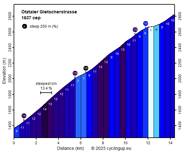
Climbing effort: 1637 cep
Elevation meters: 1497
Steepest kilometer: 13.4%
Steepest 250 m: 15%
Foot: 1370 m Top: 2830 m
Mean slope: 10.1%
Length: 14.4 km
From: Sölden
Road conditions (2015): good
Other race bikers: 5-10 per hour
Motor vehicles: 10-30 per hour
Scenery and road:
Restaurant or bar near top: yes
PHOTOS VIDEO Download gpx

The Ötztaler Gletscherstrasse is, with its highest point at 2830 m, the highest paved road in the Alps. Also, it is an utterly steep one. Therefore, you'll need a very small gear and an excellent shape. Otherwise this trip probably becomes an ordeal or it is simply impossible to accomplish it. I drove here on my hybrid bike, because it has lower gears than my race bike. That way I made it. The ascent begins, if one drives southward on the main road through Sölden, where the road gets steeper. The gradient is significant (8%) but this is nothing compared to what lies ahead. After 700 meters a side road is taken to the right in the direction of the Rettenbach- and the Tiefenbachferner (Ferner is Austrian for glacier) and all hell breaks loose. From here to the finish there are 28 five hundred-meter intervals. Of these, 23 have a gradient ranging from 9 to 14%. Hence, climbing is almost continuously very hard. An exception is, after six kilometers, a short descent to the tollgate. At the elevation of 2630 meters the road bifurcates. The branch to the left leads to the Tiefenbachferner, the one to the right to the Rettenbachferner. Both options have exactly the same index of hardness, namely 1637 climb effort points. The data, the profile and the map of this website relate to the branch to the Tiefenbachferner, because this leads to the famous point at the elevation of 2830 m. Taking this option, the road soon loses 20 elevation meters and it ends with a 1800 meters long, fairly well-lit tunnel (Rosi-Mittermaier-Tunnel). At its exit the highest paved street point in the Alps is reached. The alternative from the bifurcation, the road to the Rettenbachferner, provides no opportunity for regeneration. The remaining one and a half kilometers to the top are utterly steep, with a steepest kilometer of 13.2%. The end is at 2798 meters. Here you will see a monument with the text "Highest road in the EU". It was moved to this place because there is no parking at the end of Rosi Mittermaier-Tunnel. Finally, it should be noted that the road is wide, that the pavement is excellent (in 2015) and that the mountains are beautiful. Without ski lifts, ski slopes and the barren road, it would be even nicer.


Rijd op 22 maart deze prachtige tocht over de Veluwe, 75 of 125 kilometer vanuit Wageningen. Met veel hoogtemeters: resp. 550 en 970. Inschrijving
1K Ride
Rijd op 15 juni deze tocht met meer dan 1000 hoogtemeters; 80, 120 of 145 kilometer vanuit Oosterbeek. Inschrijving
Tour for Life
Rijdt deze zomer de unieke en klassieke 8-daagse wielrentocht van Noord-Italië naar Zuid-Nederland voor Artsen zonder Grenzen!

