HOME cyclingup.eu

regions

method
contact
links
French Alps
Switzerland
Austria
Italian Alps
French Pyrenees
Spain
Gran Canaria
Vosges
Black Forest
Brocken, Germany
Ardennes
Netherlands
-west
CyclingUp: -west
Climbing effort: cep
Elevation meters:
Steepest kilometer: %
Steepest 250 m: %
Foot: m Top: m
Mean slope: %
Length: km
From:
Road conditions ():
Other race bikers: per hour
Motor vehicles: per hour
Scenery and road:
Restaurant or bar near top:
PHOTOS VIDEO Download gpx

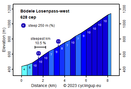
The ascent from Dornbirn to the Bödele Losenpass runs on a wide, unfortunately rather busy road and is hence not really great for cyclists. From a sporting point of view, the ride is quite challenging. While the first kilometer is still easy (4-5%), the remaining 7 kilometers are quite steep. Of the 14 five hundred meter segments, 8 have a slope of 10% and sections to recover are missing. In total, the climb bridges 700 meters in altitude. The most beautiful views arise in the first half of the ascent, mostly behind the climbing cyclist. In the second half, the road often runs through the forest. Finally, the pass appears quite suddenly and offers, to the left, a wonderful panorama on the mountains of the Allgäu Alps.
Veluviatocht
Rijd op 21 maart deze prachtige tocht vanuit Wageningen over de Veluwe. Keuze uit 80 en 125 km met resp. 580 en 990 hoogtemeters. Inschrijving vanaf 31 december
Tour for Life
Rijdt deze zomer de unieke en klassieke 8-daagse wielrentocht van Noord-Italië naar Zuid-Nederland voor Artsen zonder Grenzen!