HOME cyclingup.eu

regions

method
contact
links
French Alps
Switzerland
Austria
Italian Alps
French Pyrenees
Spain
Gran Canaria
Vosges
Black Forest
Brocken, Germany
Ardennes
Netherlands
Bödele Losenpass-east
CyclingUp: Bödele Losenpass-east
Climbing effort: 372 cep
Elevation meters: 444
Steepest kilometer: 9.9%
Steepest 250 m: 12%
Foot: 696 m Top: 1140 m
Mean slope: 7.9%
Length: 5.6 km
From: Schwarzenberg
Road conditions (2022): good
Other race bikers: 0-1 per hour
Motor vehicles: 60-180 per hour
Scenery and road:
Restaurant or bar near top: yes
PHOTOS
W SIDE Download gpx
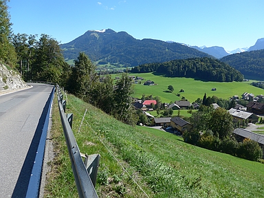

The ascent to the Bödele Losenpass from the east (Schwarzenberg) described here is more scenic than the ascent from Dornbirn, located on the other side of the pass. During the climb there are wide views in north-easterly and easterly direction of the high, green hills of the Bregenzerwald with the Allgäu Alps in the background. I cycled here on a sunny, clear September day, when the highest parts of the mountains were covered with snow. Very beautiful! The climb is short (5.6 kilometers) and only 444 meters in altitude are overcome. The road often has a gradient of 8 or 9% but there are some steeper outliers (including three 250 meter sections of 11-12%).
Germania klimtocht
Rijd op 30 augustus deze prachtige klimtocht vanuit Wageningen over de Veluwe, door Montferland, Reichswald en Rijk van Nijmegen. Keuze uit 105 en 155 km met resp. 750 en 1130 hoogtemeters. Inschrijven vanaf 22 juni
Tour for Life
Rijdt deze zomer de unieke en klassieke 8-daagse wielrentocht van Noord-Italië naar Zuid-Nederland voor Artsen zonder Grenzen!