
Flexenpass-north
CyclingUp: Flexenpass-north
Region: Austria
Climbing effort: 412 cep
Elevation meters: 773
Steepest kilometer: 7.5%
Steepest 250 m: 10%
Foot: 1120 m Top: 1773 m
Mean slope: 2.8%
Length: 23.6 km
From: Steeg
Road conditions (2021): good
Other race bikers: 1-5 per hour
Motor vehicles: 60-180 per hour
Scenery and road:
![]() (2/5)
(2/5)
Restaurant or bar near top: no
PHOTOS
S SIDE
Download gpx
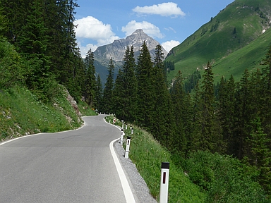

The ascent from Steeg in the Lechtal to the Flexenpass is long (23.6 kilometers) but with only four 500 meter segments steeper than 6% not really hard. Over the first more than 10 kilometers the slope of the road varies greatly (-5 to 8 percent). These kilometers are identical with the first of the ascent from the east to the Hochtannbergpass. The separation of the two climbs occurs in Warth. After that village the most beautiful part of the ride follows, in which the almost horizontal street is located high above the base of the Lech Valley. The valley is steep, the road narrow and mountains tower beautifully above the green valley. After seven kilometers you will reach Lech, the village where the Dutch royal family uses to spend their skiing holidays. Immediately after Lech the steepest kilometer of the climb (7.5%) begins. After that, two awful galleries (up to 6%) are waiting, in which motorized traffic drives at high speed producing lots of noise. A little further, the road passes through Zürs. From there a little more than a kilometer remains to the pass (5-6%).
Rijdt deze zomer de unieke en klassieke 8-daagse wielrentocht van Noord-Italië naar Zuid-Nederland voor Artsen zonder Grenzen!