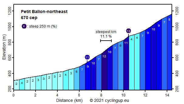
Petit Ballon-northeast

CyclingUp: Petit Ballon-northeast

Climbing effort: 670 cep
Elevation meters: 861
Steepest kilometer: 11.1%
Steepest 250 m: 13%
Foot: 310 m Top: 1163 m
Mean slope: 5.9%
Length: 14.4 km
From: Soultzbach-les-Bains
Road conditions (2014): good
Other race bikers: 0-1 per hour
Motor vehicles: 10-30 per hour
Scenery and road:
Restaurant or bar near top: no
PHOTOS Download gpx

This is one my preferred climbs in the Vosges. It offers both interesting scenic and hard parts and it is variable. After entering the D43 near Soultzbach-les-Bains, the first 6 kilometers in the valley of the Krebsbach are easy with a slope of 2-5%. In the village of Wasserbourg keep to the right and follow the signs to Le Petit Ballon and Ried. Here the party begins with a steep stretch at the end of the village. The next four kilometers are cycled on a narrow, winding and very well paved road. It contains the steepest kilometer (11.1%) that I have found so far (July 2014) in the Vosges. It is followed by a short descent (8 m) to the hamlet of Ried. From there the climb takes a wider but still quiet road, first through forests but the final 2 kilometers of the trip take place in the typical open landscape of the highest parts of the Vosges. Steepness is variable here with slopes up to 10%. From the highest point of the road (at 1163 m), a short walk of another 100 elevation meters leads to the summit of Le Petit Ballon.


Rijd op 22 maart deze prachtige tocht over de Veluwe, 75 of 125 kilometer vanuit Wageningen. Met veel hoogtemeters: resp. 550 en 970. Inschrijving
1K Ride
Rijd op 15 juni deze tocht met meer dan 1000 hoogtemeters; 80, 120 of 145 kilometer vanuit Oosterbeek. Inschrijving
Tour for Life
Rijdt deze zomer de unieke en klassieke 8-daagse wielrentocht van Noord-Italië naar Zuid-Nederland voor Artsen zonder Grenzen!

