HOME cyclingup.eu

regions

method
contact
links
French Alps
Switzerland
Austria
Italian Alps
French Pyrenees
Spain
Gran Canaria
Vosges
Black Forest
Brocken, Germany
Ardennes
Netherlands
Col du Wettstein-south
CyclingUp: Col du Wettstein-south
Climbing effort: 237 cep
Elevation meters: 432
Steepest kilometer: 6.4%
Steepest 250 m: 8%
Foot: 450 m Top: 882 m
Mean slope: 5.3%
Length: 8.2 km
From: Stosswihr
Road conditions (2014): good
Other race bikers: 0-1 per hour
Motor vehicles: 10-30 per hour
Scenery and road:
Restaurant or bar near top: no
PHOTOS Download gpx

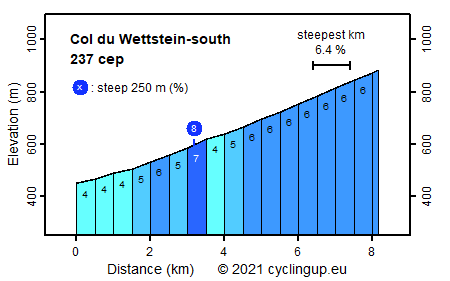
This is not a very exiting climb. The elevation gain is limited (432 m) and the slope is mostly 6% and hardly more than that. The trip begins just south of Stosswihr where the D417 starts to get somewhat steeper (4%). During the first 3 kilometers we follow the D417, which is, due to the still densely populated area, quite busy here. The character abruptly changes when we take the D48 where it bifurcates from the D417. From there up to the col the road gains elevation with a number of hairpin bends (6), passing through farmlands. There are beautiful panoramas of the Vallée de Munster and traffic is scarce. A military cemetery for French soldiers perished during the First World War is situated at the col.
Veluviatocht
Rijd op 21 maart deze prachtige tocht vanuit Wageningen over de Veluwe. Keuze uit 80 en 125 km met resp. 580 en 990 hoogtemeters. Inschrijving vanaf 31 december
Tour for Life
Rijdt deze zomer de unieke en klassieke 8-daagse wielrentocht van Noord-Italië naar Zuid-Nederland voor Artsen zonder Grenzen!