Col du Platzerwasel

CyclingUp: Col du Platzerwasel

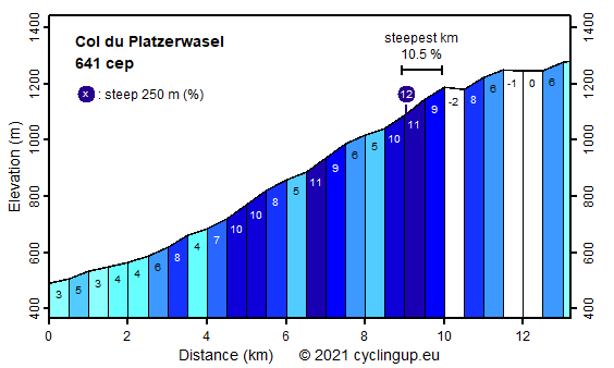
Climbing effort: 641 cep
Elevation meters: 817
Steepest kilometer: 10.5%
Steepest 250 m: 12%
Foot: 490 m Top: 1282 m
Mean slope: 6.0%
Length: 13.2 km
From: Metzeral
Road conditions (2014): good
Other race bikers: 1-5 per hour
Motor vehicles: 30-60 per hour
Scenery and road:
Restaurant or bar near top: no
PHOTOS Download gpx

The Col du Platzerwasel is interesting because it is hard and because it is an almost unavoidable climb in the Vosges providing access to the Route des Crêtes from the east. After the start in Metzeral the first 3 kilometers with a 3-6% slope are relatively easy. The route heads southward, passes Sondernach and then suddenly bends back to the north and true climbing begins. The following 7 kilometers are hard with an alternation of really steep parts (10-11%) and parts with a slope of 4-5% that allow some recuperation. The dense forest does not allow any view. At the elevation of 1193 meter the Col du Platzerwasel proper is reached but this is not all. The true finish and the end of our route is Le Breitfirst (1282 m), which takes another 3 kilometers with 2 short descends and another 124 meters to climb, adding 83 climb effort points to the 558 of the Platzerwasel proper.


Rijd op 22 maart deze prachtige tocht over de Veluwe, 75 of 125 kilometer vanuit Wageningen. Met veel hoogtemeters: resp. 550 en 970. Inschrijving
1K Ride
Rijd op 15 juni deze tocht met meer dan 1000 hoogtemeters; 80, 120 of 145 kilometer vanuit Oosterbeek. Inschrijving
Tour for Life
Rijdt deze zomer de unieke en klassieke 8-daagse wielrentocht van Noord-Italië naar Zuid-Nederland voor Artsen zonder Grenzen!

