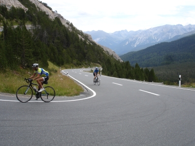
Ofenpass-east

CyclingUp: Ofenpass-east

Climbing effort: 618 cep
Elevation meters: 792
Steepest kilometer: 10.1%
Steepest 250 m: 11%
Foot: 1370 m Top: 2149 m
Mean slope: 5.7%
Length: 13.6 km
From: Santa Maria
Road conditions (2015): excellent
Other race bikers: 5-10 per hour
Motor vehicles: >180 per hour
Scenery and road:
Restaurant or bar near top: yes
PHOTOS VIDEO Download gpx

The climb to the Ofenpass (Pass dal Fuorn in Rhaeto-Romance) from Santa Maria takes place in the Münstertal (Val Müstair). In this valley 60-80% of the population speaks Rhaeto-Romance, the fourth language of Switzerland. After a quiet start of one and a half kilometers there is a steep (9%) ramp in the village of Valchava. Over the next three kilometers it goes uphill but the road is gradually getting less steep. Then four easy kilometers follow. However, on passing the village of Tschierv climbing becomes a serious matter and that does not change in the remaining five kilometers to the pass. The slope is with large (Swiss?) constancy 9-10%, except for a less steep passage about a kilometer before the finish. Unfortunately, the traffic is quite strong. The broad valley is beautiful but not overwhelming. The ascent can be extended with the stretch from Glurns (Glorienza) in Italy to Santa Maria. This brings another 14.4 kilometers, 474 meters of altitude and 250 climb effort points.


Rijd op 30 augustus deze prachtige klimtocht vanuit Wageningen over de Veluwe, door Montferland, Reichswald en Rijk van Nijmegen. Keuze uit 105 en 155 km met resp. 750 en 1130 hoogtemeters. Inschrijven vanaf 22 juni
Tour for Life
Rijdt deze zomer de unieke en klassieke 8-daagse wielrentocht van Noord-Italië naar Zuid-Nederland voor Artsen zonder Grenzen!

