HOME cyclingup.eu

regions

method
contact
links
French Alps
Switzerland
Austria
Italian Alps
French Pyrenees
Spain
Gran Canaria
Vosges
Black Forest
Brocken, Germany
Ardennes
Netherlands
Nufenenpass-west
CyclingUp: Nufenenpass-west
Climbing effort: 1025 cep
Elevation meters: 1138
Steepest kilometer: 10.2%
Steepest 250 m: 12%
Foot: 1342 m Top: 2478 m
Mean slope: 8.4%
Length: 13.5 km
From: Ulrichen
Road conditions (2010): good
Other race bikers: 1-5 per hour
Motor vehicles: 10-30 per hour
Scenery and road:
Restaurant or bar near top: yes
PHOTOS Download gpx

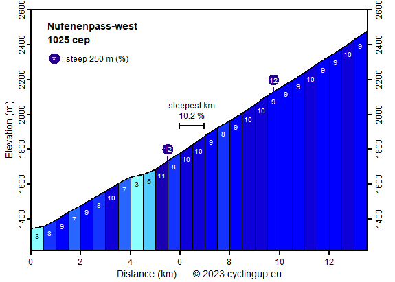
Starts in the wide Rhonevalley at the point, where the road from Ulrichen to the pass crosses the river. Soon there is a steep part (7-10%) of about 3 km long ending in the straight and narrow Agenetal. The first part in this valley is the only easy part of the climb. A kilometer later the road starts to become steeper again and this sets the stage for the remaining 800 elevation meters, which are relentless with a slope of mostly 9 or 10%. The award must be a magnificent landscape if I believe the pictures that can be found on the Internet (I personally only saw clouds). The low traffic density makes the Nufenenpass very suitable for race bikers.
Veluviatocht
Rijd op 22 maart deze prachtige tocht over de Veluwe, 75 of 125 kilometer vanuit Wageningen. Met veel hoogtemeters: resp. 550 en 970. Inschrijving
1K Ride
Rijd op 15 juni deze tocht met meer dan 1000 hoogtemeters; 80, 120 of 145 kilometer vanuit Oosterbeek. Inschrijving
Tour for Life
Rijdt deze zomer de unieke en klassieke 8-daagse wielrentocht van Noord-Italië naar Zuid-Nederland voor Artsen zonder Grenzen!