
Ferpècle
CyclingUp: Ferpècle
Climbing effort: 388 cep
Elevation meters: 504
Steepest kilometer: 9.2%
Steepest 250 m: 11%
Foot: 1450 m Top: 1890 m
Mean slope: 5.2%
Length: 8.5 km
From: Les_Haudères
Road conditions (2025): average
Other race bikers: 1-5 per hour
Motor vehicles: 30-60 per hour
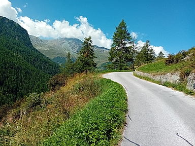
Scenery and road:
Restaurant or bar near top: no
PHOTOS Download gpx

When riding upwards in the Val d’Hérens,
the valley and the road split into two branches at Les Haudères.
This climb starts in that village at the fork of the road
and finishes at the end of the asphalt
in the side valley on the left-hand side.
The final kilometres of the route are magnificent.
Riding through forest, mainly larches,
there are views of extremely high Alpine giants,
of which the Dent Blanche
(on the left-hand side of the valley’s longitudinal axis
for the climbing cyclist)
is the highest (4357 metres).
It is a pity that the sun was already quite low
above the highest peaks when I biked here.
As a result, the view of the mountains was rather hazy.
The profile can be divided into three parts.
The first 3.5 kilometres to Forclaz are the hardest,
including the steepest kilometre of the entire route (9.2%).
After that, 55 metres of elevation are lost in a descent.
Finally, in the beautiful final section,
the gradient varies considerably
(5 to 9% for the 500-metre segments).
Attention: about 1 kilometre before the end of the climb,
one should continue riding
despite a few dozen metres of poor asphalt
and a round white traffic sign with a red border!
Rijd op 21 maart deze prachtige tocht vanuit Wageningen over de Veluwe. Keuze uit 80 en 125 km met resp. 580 en 990 hoogtemeters. Inschrijving vanaf 31 december
Tour for Life
Rijdt deze zomer de unieke en klassieke 8-daagse wielrentocht van Noord-Italië naar Zuid-Nederland voor Artsen zonder Grenzen!