
Luz-Ardiden
CyclingUp: Luz-Ardiden
Climbing effort: 825 cep
Elevation meters: 1030
Steepest kilometer: 10.3%
Steepest 250 m: 12%
Foot: 685 m Top: 1715 m
Mean slope: 7.6%
Length: 13.5 km
From: Luz-St-Sauveur
Road conditions (2014): good
Other race bikers: 5-10 per hour
Motor vehicles: 10-30 per hour
Scenery and road:
Restaurant or bar near top: no
PHOTOS VIDEO Download gpx

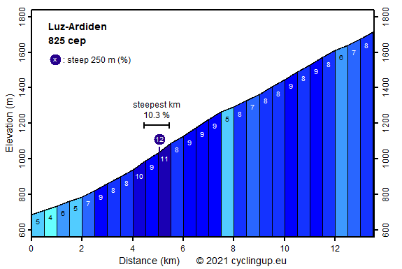
The climb to Luz-Ardiden reminds of that to Alpe d'Huez. Both climbs are steep with the first half being steeper than the second half and both end at a ski resort. Both have been the finish location of many Tour de France stages though the frequency is less for Luz-Ardiden than for Alpe d'Huez (8 against 18 during 1985-2011). Also, in other aspects Luz-Ardiden is less than its counterpart in the Alps. There are far fewer cyclists and cars and Luz-Ardiden has fewer elevation meters, though only 86. As mentioned, the steepest part of the ascent (8-11%) lies in the first half. It starts just before the village of Sazos and includes the stretch with 8 hairpin bends before and after the village of Grust. In the upper part the forests give way to a more open landscape. Note that with less than 2 kilometers to go, one has to turn sharply to the left in the direction of Aulian. I have no idea about the panoramas and the ski lifts that must be visible during the final part. A dense fog inhibited to see anything but the nearest 20 meters.
Rijd op 21 maart deze prachtige tocht vanuit Wageningen over de Veluwe. Keuze uit 80 en 125 km met resp. 580 en 990 hoogtemeters. Inschrijving vanaf 31 december
Tour for Life
Rijdt deze zomer de unieke en klassieke 8-daagse wielrentocht van Noord-Italië naar Zuid-Nederland voor Artsen zonder Grenzen!