Hautacam

CyclingUp: Hautacam

Climbing effort: 978 cep
Elevation meters: 1191
Steepest kilometer: 11.3%
Steepest 250 m: 12%
Foot: 430 m Top: 1615 m
Mean slope: 7.4%
Length: 16.0 km
From: Argelès-Gazost
Road conditions (2014): excellent
Other race bikers: 5-10 per hour
Motor vehicles: 60-180 per hour
Scenery and road:
Restaurant or bar near top: yes
PHOTOS Download gpx

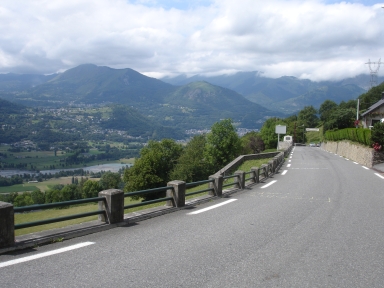
The Hautacam is a well-known ascent due to the Tour de France with five finishes during the period from 1994 to 2014. It is named after a small ski domain. The climb to the Hautacam is a steep one with six 500 meter stretches of 10 or 11%. Moreover, the slope varies quite a lot, especially during the first 7 kilometers, which is to a large extent not shown by the profile shown here because the variation is not resolved by the 500 meter steps. The steepest part of the climb lies between kilometers 7 and 10. The final 4 kilometers, leading through a somewhat barren landscape, are easier (mostly 7-8%). The Tour de France stage finishes at the parking lot at 1520 m but in fact the ascent continues across this place and then, after some 200 meters, turns to the left. The road leads to the Col de Tramassel and then another few hundred meters to a somewhat more elevated parking place. The climb of the Hautacam does not really provide a high-mountain feeling since high peaks are far away. However, this is compensated for by the views across the valley of the Gave de Pau, from where the ascent started, onto the mountains on the opposite side of that valley.


Rijd op 21 maart deze prachtige tocht vanuit Wageningen over de Veluwe. Keuze uit 80 en 125 km met resp. 580 en 990 hoogtemeters. Inschrijving vanaf 31 december
Tour for Life
Rijdt deze zomer de unieke en klassieke 8-daagse wielrentocht van Noord-Italië naar Zuid-Nederland voor Artsen zonder Grenzen!

