Col de Tentes

CyclingUp: Col de Tentes

Climbing effort: 1015 cep
Elevation meters: 1524
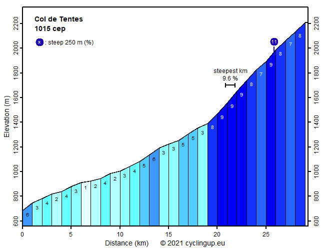
Steepest kilometer: 9.6%
Steepest 250 m: 11%
Foot: 684 m Top: 2208 m
Mean slope: 5.2%
Length: 29.3 km
From: Luz-St-Sauveur
Road conditions (2014): moderate
Other race bikers: 5-10 per hour
Motor vehicles: <10 per hour
Scenery and road:
Restaurant or bar near top: no
PHOTOS VIDEO Download gpx

When I climbed to the Col de Tentes, I experienced the first few kilometers after Gavarnie as the nicest part of the tour. Partly, because there is the feeling of relief after the road from Luz-St-Sauveur to Gavarnie, which can be so busy with tourists heading towards the UNESCO World Heritage Site of the Cirque de Gavarnie that the cars stand in a traffic jam. Also, serious climbing begins here. The first 7 kilometers after Gavarnie the road has a slope of mostly 9%. Moreover, I found this a stretch of high scenic beauty, the surroundings consisting of mighty, steep mountain faces. Sheep may adorn the road here. The final three kilometers are more variable in steepness and on average somewhat easier than the part before. The ascent ends at the parking lot of the Col de Tentes (2208 m), which offers superb views of the central chain of the Pyrenees. From this place a bicycle path seems to continue towards the Port de Boucharo but cycling becomes impossible a few hundred meters further. The road between Gavarnie and the Col de Tentes is not in an optimal condition, with the state of the asphalt degrading towards the col.


Rijd op 22 maart deze prachtige tocht over de Veluwe, 75 of 125 kilometer vanuit Wageningen. Met veel hoogtemeters: resp. 550 en 970. Inschrijving
1K Ride
Rijd op 15 juni deze tocht met meer dan 1000 hoogtemeters; 80, 120 of 145 kilometer vanuit Oosterbeek. Inschrijving
Tour for Life
Rijdt deze zomer de unieke en klassieke 8-daagse wielrentocht van Noord-Italië naar Zuid-Nederland voor Artsen zonder Grenzen!

