Col d'Aspin-west

CyclingUp: Col d'Aspin-west

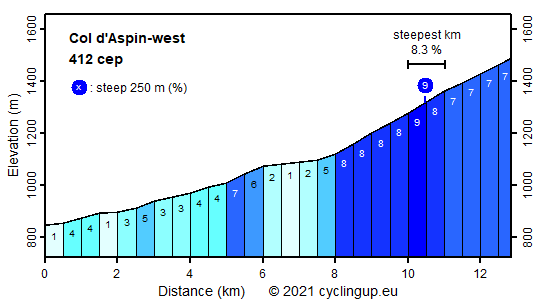
Climbing effort: 412 cep
Elevation meters: 649
Steepest kilometer: 8.3%
Steepest 250 m: 9%
Foot: 847 m Top: 1489 m
Mean slope: 5.0%
Length: 12.8 km
From: Ste-Marie-de-Campan
Road conditions (2014): excellent
Other race bikers: 5-10 per hour
Motor vehicles: 30-60 per hour
Scenery and road:
Restaurant or bar near top: no
PHOTOS VIDEO Download gpx

The Col d'Aspin is part of the chain of cols that connect valleys on the French side of the Pyrenees, namely from west to east the Aubisque, the Tourmalet, l'Aspin and the Peyresourde. As a consequence the Col d'Aspin has very frequently (71 times until 2015) been part of the Tour de France. Its western side is a very friendly one. The climb starts in the centre of Ste-Marie-Campan, at the same place where the ascent of the Tourmalet from the east begins. The first 8 kilometers up to Espiadet are not very interesting. They bridge the first 250 elevation meters with a mean slope of some 4% through the valley of Le Adour de Payolle. However, the final 5 kilometers are really nice. The road enters into the forest, narrows and becomes tranquil. The slope is steep but still pleasant (7-8 %), the asphalt is perfect, there are some nice hairpin turns and here and there openings between the trees allow views on the surroundings mountains. Also, the number of elevation meters of this final part remains friendly with about 400 meters. Another asset of this tour is the reward at the col with panoramic views backwards and in southward directions.


Rijd op 21 maart deze prachtige tocht vanuit Wageningen over de Veluwe. Keuze uit 80 en 125 km met resp. 580 en 990 hoogtemeters. Inschrijving vanaf 31 december
Tour for Life
Rijdt deze zomer de unieke en klassieke 8-daagse wielrentocht van Noord-Italië naar Zuid-Nederland voor Artsen zonder Grenzen!

