
Val di Rhêmes
CyclingUp: Val di Rhêmes
Climbing effort: 855 cep
Elevation meters: 1240
Steepest kilometer: 11.4%
Steepest 250 m: 13%
Foot: 681 m Top: 1903 m
Mean slope: 5.3%
Length: 23.1 km
From: Villeneuve
Road conditions (2024): average
Other race bikers: 1-5 per hour
Motor vehicles: 30-60 per hour
Scenery and road:
Restaurant or bar near top: yes
PHOTOS Download gpx
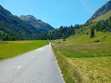

The climb from the Aosta Valley through the Val di Rhêmes is long (23 kilometres) and not steep, at least on average (5.3%). The steepest part of the ascent lies halfway the ride, starting shortly after Rhêmes-Saint-Georges. In that part, 358 metres of altitude are covered in 4 kilometres (an average of 9.0%), with the steepest kilometre sloping at over 11%. This passage also contains the first of a series of 6 tunnels. Though these are lit, I did not find my own lights an unnecessary luxury. Shortly after the tunnels, from Mélignon, reached after almost 15 kilometres of cycling, I had the first view of snow-covered mountains that close off the valley (including Pointe Calabre, 3445 m). From here on, the landscape is more beautiful and the road becomes increasingly quieter. As a whole, the Val di Rhêmes did not make the impression of being very touristy.
Rijd op 21 maart deze prachtige tocht vanuit Wageningen over de Veluwe. Keuze uit 80 en 125 km met resp. 580 en 990 hoogtemeters. Inschrijving vanaf 31 december
Tour for Life
Rijdt deze zomer de unieke en klassieke 8-daagse wielrentocht van Noord-Italië naar Zuid-Nederland voor Artsen zonder Grenzen!