
CyclingUp:
Climbing effort: cep
Elevation meters:
Steepest kilometer: %
Steepest 250 m: %
Foot: m Top: m
Mean slope: %
Length: km
From:
Road conditions ():
Other race bikers: per hour
Motor vehicles: per hour
Scenery and road:
Restaurant or bar near top:
PHOTOS VIDEO Download gpx
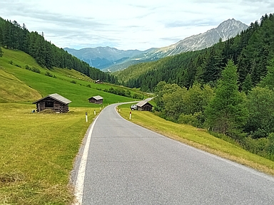
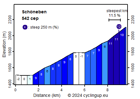
Most cyclists make this climb from Reschen (Resia in Italian) to Schöneben (Belpiano) in the gondola lift, and then descend on their downhill bikes or enduro mountain bikes. For road bikers this ride starts with one and a half horizontal kilometers. After that the winding and moderately paved (as of 2023) road runs steeply uphill (largely 8-9%) for 3.5 kilometers. The following parts are a descent (21 meters in altitude) and the most scenic part of the ascent through the Rojental (Valle Roia), about 2 kilometers long at 6-9%. Finally, the road turns sharply to the left - there is a dead end road sign here - and the last one and a half kilometers begin. These are quite steep and include the steepest kilometer of the ride (11.5%). At the finish, the view is composed mainly of buildings and the like that belong to the gondola lift.
Rijd op 21 maart deze prachtige tocht vanuit Wageningen over de Veluwe. Keuze uit 80 en 125 km met resp. 580 en 990 hoogtemeters. Inschrijving vanaf 31 december
Tour for Life
Rijdt deze zomer de unieke en klassieke 8-daagse wielrentocht van Noord-Italië naar Zuid-Nederland voor Artsen zonder Grenzen!