HOME cyclingup.eu

regions

method
contact
links
French Alps
Switzerland
Austria
Italian Alps
French Pyrenees
Spain
Gran Canaria
Vosges
Black Forest
Brocken, Germany
Ardennes
Netherlands
Cruz de Tejeda-southwest
CyclingUp: Cruz de Tejeda-southwest
Climbing effort: 277 cep
Elevation meters: 510
Steepest kilometer: 6.9%
Steepest 250 m: 8%
Foot: 1025 m Top: 1519 m
Mean slope: 5.0%
Length: 9.9 km
From: Tejeda
Road conditions (2022): excellent
Other race bikers: 0-1 per hour
Motor vehicles: <10 per hour
Scenery and road:
Restaurant or bar near top: yes
PHOTOS Download gpx

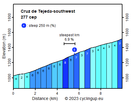
There are two ways to cycle up from Tejeda to the Cruz de Tejada, namely via the GC-15 and via the combination of the GC-608 and the GC-156. On this website the first variant is part of the northwest ascent to the Pico de las Nieves. The second variant is described here and starts at the bridge of the GC-60 over the Barranco de Tejeda, 1 km south of Tejeda. It is less steep (maximum 8%) than the alternative via the GC-15, there is hardly any traffic, the road surface is almost perfect and, as with the alternative, the panoramic view is outstanding. In short, this is a wonderful climb for road cyclists.
Veluviatocht
Rijd op 21 maart deze prachtige tocht vanuit Wageningen over de Veluwe. Keuze uit 80 en 125 km met resp. 580 en 990 hoogtemeters. Inschrijving vanaf 31 december
Tour for Life
Rijdt deze zomer de unieke en klassieke 8-daagse wielrentocht van Noord-Italië naar Zuid-Nederland voor Artsen zonder Grenzen!