HOME cyclingup.eu

regions

method
contact
links
French Alps
Switzerland
Austria
Italian Alps
French Pyrenees
Spain
Gran Canaria
Vosges
Black Forest
Brocken, Germany
Ardennes
Netherlands
les Orres
CyclingUp: les Orres
Climbing effort: 685 cep
Elevation meters: 973
Steepest kilometer: 8.9%
Steepest 250 m: 10%
Foot: 789 m Top: 1745 m
Mean slope: 5.8%
Length: 16.6 km
From: Embrun
Road conditions (2020): good
Other race bikers: 5-10 per hour
Motor vehicles: 60-180 per hour
Scenery and road:
Restaurant or bar near top: no
PHOTOS Download gpx

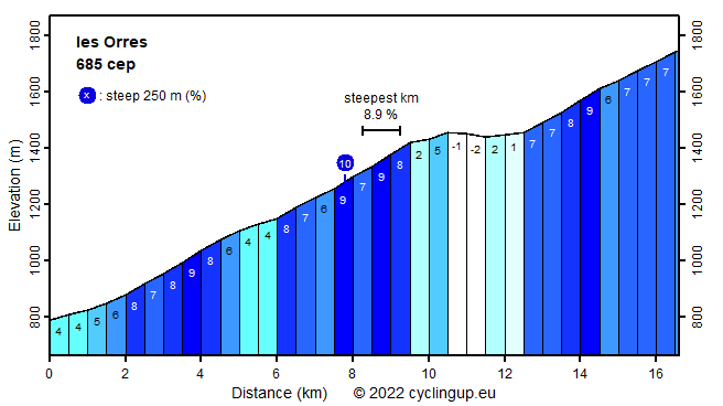
In terms of elevation meters (973) the climb from Embrun to the highest part of les Orres (the winter sports resort les Orres 1800) is an almost average ascent. Because the slope varies quite a bit, long, steep sections are missing. But actually the road is nowhere really steep; not a single 500 meter segment exceeds 9%. During the ride wide views in northern and western direction can be enjoyed. The road is wide, busy with traffic and has a good surface but unfortunately there is hardly any shade. When you get to Les Orres 1800, you should, at the T-junction, continue straight ahead and not turn left, and then continue cycling to the highest point of the road.
Camping Les Erables .
Tip!
Ideal starting point for Col du Grand Colombier and Col de la Biche.
Warm hospitality and swimming pool nearby.
Veluviatocht
Rijd op 21 maart deze prachtige tocht vanuit Wageningen over de Veluwe. Keuze uit 80 en 125 km met resp. 580 en 990 hoogtemeters. Inschrijving vanaf 31 december
Tour for Life
Rijdt deze zomer de unieke en klassieke 8-daagse wielrentocht van Noord-Italië naar Zuid-Nederland voor Artsen zonder Grenzen!