les Confins

CyclingUp: les Confins

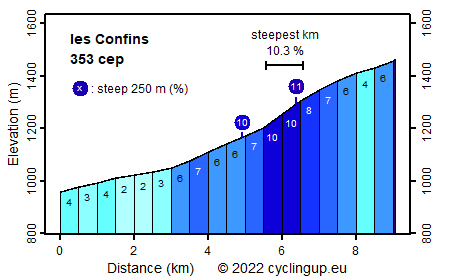
Climbing effort: 353 cep
Elevation meters: 508
Steepest kilometer: 10.3%
Steepest 250 m: 11%
Foot: 959 m Top: 1464 m
Mean slope: 5.6%
Length: 9.1 km
From: St-Jean-de-Sixt
Road conditions (2019): average
Other race bikers: 0-1 per hour
Motor vehicles: >180 per hour
Scenery and road:
Restaurant or bar near top: no
PHOTOS Download gpx

The climb from St-Jean-de-Sixt to les Confins
is not really difficult with only 508 elevation meters.
The first three kilometers from St-Jean to La Clusaz are even easy (2-4%).
After this winter sports resort, the road becomes a little steeper (6-7%)
and two kilometers further on,
just before the first hairpin turn,
the hardest part of the ascent begins.
Here the steepest kilometer of the trip (10.3%) is found.
After that, the remaining more than two kilometers are not really hard (4-8%).
Unfortunately there are buildings along the street almost everywhere.
In addition, the road is quite busy
so the tour is not the most scenic one.
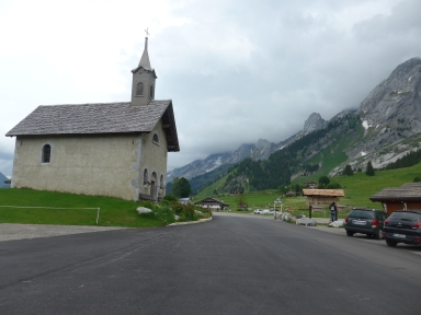
However, after Clusaz there is a beautiful view of the Chaîne des Aravis.
The climb can be extended with the ride from Thônes
to St-Jean-de-Sixt.
That adds another 164
climb effort points (cep) and 332 elevation meters.
Unfortunately, this extension takes place on a road
with a lot of fast driving traffic in an unimpressive landscape.


Rijd op 22 maart deze prachtige tocht over de Veluwe, 75 of 125 kilometer vanuit Wageningen. Met veel hoogtemeters: resp. 550 en 970. Inschrijving
1K Ride
Rijd op 15 juni deze tocht met meer dan 1000 hoogtemeters; 80, 120 of 145 kilometer vanuit Oosterbeek. Inschrijving
Tour for Life
Rijdt deze zomer de unieke en klassieke 8-daagse wielrentocht van Noord-Italië naar Zuid-Nederland voor Artsen zonder Grenzen!

