
l'Orgère
CyclingUp: l'Orgère
Climbing effort: 769 cep
Elevation meters: 918
Steepest kilometer: 10.0%
Steepest 250 m: 11%
Foot: 1033 m Top: 1945 m
Mean slope: 7.5%
Length: 12.2 km
From: Freney
Road conditions (2025): good
Other race bikers: 0-1 per hour
Motor vehicles: 10-30 per hour
Scenery and road:
Restaurant or bar near top: yes
PHOTOS Download gpx
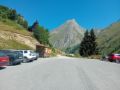
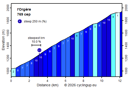
This climb from the Arc valley up to the car park near the Refuge de l’Orgère overcomes a substantial number of elevation metres (912). The gradients of the 500-metre segments vary between 7 and 10%, with the exception of the first 500 metres and three sections in the second half of the route (1–5%). These less steep sections make the second half of the climb easier than the first half. On a beautiful summer day I encountered only two other cyclists during this ride. Perhaps many people are aware that there are only limited views of imposing mountains along the way. In the sparsely wooded first 3 kilometres of the climb, the view is mainly down into the densely populated Arc valley. After that, the mountains are mostly hidden behind trees. Spectacular, however, is the view of the Pointe de l’Échelle (3418 metres) from the car park where the route ends. Because the first, open part of the route runs along a south-facing slope, it can become quite hot there during warm, sunny weather.
Rijd op 21 maart deze prachtige tocht vanuit Wageningen over de Veluwe. Keuze uit 80 en 125 km met resp. 580 en 990 hoogtemeters. Inschrijving vanaf 31 december
Tour for Life
Rijdt deze zomer de unieke en klassieke 8-daagse wielrentocht van Noord-Italië naar Zuid-Nederland voor Artsen zonder Grenzen!