HOME cyclingup.eu

regions

method
contact
links
French Alps
Switzerland
Austria
Italian Alps
French Pyrenees
Spain
Gran Canaria
Vosges
Black Forest
Brocken, Germany
Ardennes
Netherlands
Gros
CyclingUp: Gros
Climbing effort: 371 cep
Elevation meters: 498
Steepest kilometer: 10.0%
Steepest 250 m: 11%
Foot: 889 m Top: 1385 m
Mean slope: 6.6%
Length: 7.5 km
From: Eygliers_Gare
Road conditions (2020): average
Other race bikers: 0-1 per hour
Motor vehicles: <10 per hour
Scenery and road:
Restaurant or bar near top: no
PHOTOS Download gpx
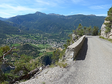

The ascent from the N94 at Gare d'Eygliers to Gros is well suited as a short training ride. The tour bridges almost 500 elevation meters and includes a steepest section of two and a half kilometers in length, starting just past the village of Eygliers, with a gradient of 8-10%. The climb has two great charms: almost no traffic and splendid views of the mountains all around including the Écrins, on Guillestre, on Mont-Dauphin, a fortress from the time of Louis XIV, and on the Guil, the river that forms the axis of the Queyras. Over the last two kilometers the asphalt surface is miserable.
Camping Les Erables .
Tip!
Ideal starting point for Col du Grand Colombier and Col de la Biche.
Warm hospitality and swimming pool nearby.
Veluviatocht
Rijd op 21 maart deze prachtige tocht vanuit Wageningen over de Veluwe. Keuze uit 80 en 125 km met resp. 580 en 990 hoogtemeters. Inschrijving vanaf 31 december
Tour for Life
Rijdt deze zomer de unieke en klassieke 8-daagse wielrentocht van Noord-Italië naar Zuid-Nederland voor Artsen zonder Grenzen!