HOME cyclingup.eu

regions

method
contact
links
French Alps
Switzerland
Austria
Italian Alps
French Pyrenees
Spain
Gran Canaria
Vosges
Black Forest
Brocken, Germany
Ardennes
Netherlands
Col du Frêne-south
CyclingUp: Col du Frêne-south
Climbing effort: 477 cep
Elevation meters: 668
Steepest kilometer: 8.3%
Steepest 250 m: 10%
Foot: 282 m Top: 950 m
Mean slope: 6.7%
Length: 9.9 km
From: St-Pierre-d'Albigny
Road conditions (2012): good
Other race bikers: 5-10 per hour
Motor vehicles: 10-30 per hour
Scenery and road:
Restaurant or bar near top: no
PHOTOS Download gpx
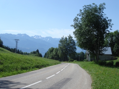
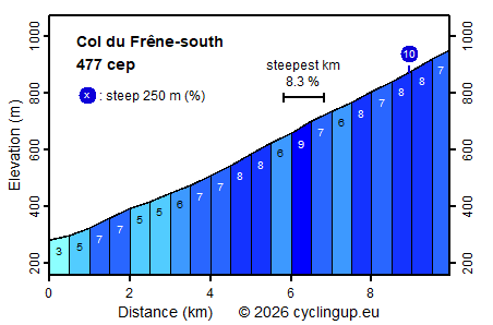
Starts at the round about near the Lac de Carouge. The first 4 km are moderately steep (mostly 5-7 %) and wind first through agricultural land and then through the diverse settlements of Saint Pierre d'Albigny. At the last settlement the steepness increases up to 7-8 %, which sets the standard up to the pass, which is reached after a total of 9.9 km and 670 elevation meters. The climb is popular among race bikers, which are probably mostly local. There is little traffic and road conditions are good.
Camping Les Erables .
Tip!
Ideal starting point for Col du Grand Colombier and Col de la Biche.
Warm hospitality and swimming pool nearby.
Veluviatocht
Rijd op 21 maart deze prachtige tocht vanuit Wageningen over de Veluwe. Keuze uit 80 en 125 km met resp. 580 en 990 hoogtemeters. Inschrijving vanaf 31 december
Tour for Life
Rijdt deze zomer de unieke en klassieke 8-daagse wielrentocht van Noord-Italië naar Zuid-Nederland voor Artsen zonder Grenzen!