


Col de la Colombière-southwest

CyclingUp: Col de la Colombière-southwest

Climbing effort: 450 cep
Elevation meters: 723
Steepest kilometer: 8.0%
Steepest 250 m: 10%
Foot: 887 m Top: 1607 m
Mean slope: 5.6%
Length: 12.9 km
From: St-Jean-de-Sixt
Road conditions (2019): good
Other race bikers: 5-10 per hour
Motor vehicles: 60-180 per hour
Scenery and road:
 (3/5)
(3/5) Restaurant or bar near top: yes
PHOTOS
NE SIDE Download gpx
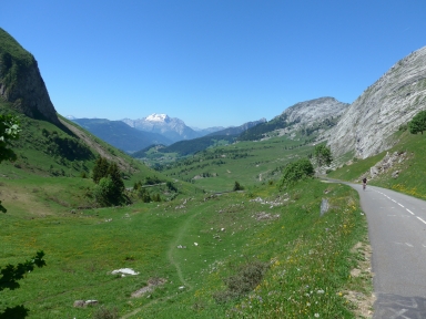
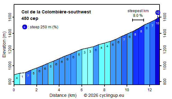
The climb to the Col de la Colombière from St-Jean-de-Sixt consists of two parts with their own character. The first part begins at the bridge of the road from St-Jean to Le Grand Bornand (D4) over the Borne. The street is wide and there is a lot of fast moving traffic. After turning left at Le Grand Bornand, the traffic becomes somewhat less unpleasant and the road gets a little steeper (6%). The built-up area only comes to an end when leaving le Chinaillon, after eight and a half of the thirteen kilometers to the pass. This is where the second, much more pleasant part of the ascent begins. There are no more houses and the slope becomes more serious (6-8%). Besides, one can now enjoy the beautiful landscape, especially the Pointe Percée (2750 meters) that lies in the direction of cycling just after le Chinaillon and the mountain range to the left of the road (Chaîne du Bargy). The last few hundred meters before the pass are the steepest of the whole climb (10%).
Rijd op 29 augustus deze prachtige klimtocht vanuit Wageningen over de Veluwe, door Montferland, Reichswald en Rijk van Nijmegen. Keuze uit 105 en 155 km met resp. 800 en 1180 hoogtemeters. Inschrijving vanaf nu
Tour for Life
Rijdt deze zomer de unieke en klassieke 8-daagse wielrentocht van Noord-Italië naar Zuid-Nederland voor Artsen zonder Grenzen!