HOME cyclingup.eu

regions

method
contact
links
French Alps
Switzerland
Austria
Italian Alps
French Pyrenees
Spain
Gran Canaria
Vosges
Black Forest
Brocken, Germany
Ardennes
Netherlands
Col de Romeyère-south
CyclingUp: Col de Romeyère-south
Climbing effort: 246 cep
Elevation meters: 406
Steepest kilometer: 8.0%
Steepest 250 m: 10%
Foot: 662 m Top: 1068 m
Mean slope: 5.1%
Length: 8.0 km
From: La_Balme-de-Rencurel
Road conditions (2018): good
Other race bikers: 5-10 per hour
Motor vehicles: 30-60 per hour
Scenery and road:
Restaurant or bar near top: yes
PHOTOS Download gpx

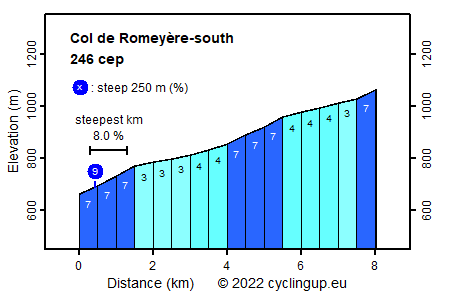
On a nice summer day we cycled through the Gorges de la Bourne, where there was dense traffic, and turned right onto the road to Col de la Romeyère. The relative peace was wonderful in a still very beautiful landscape. The ascent to the pass is not a big effort. There are only 406 elevation meters, which are not really steep. The beginning is the hardest part with a steepest kilometer of 8.0%.
Camping Les Erables .
Tip!
Ideal starting point for Col du Grand Colombier and Col de la Biche.
Warm hospitality and swimming pool nearby.
Veluviatocht
Rijd op 21 maart deze prachtige tocht vanuit Wageningen over de Veluwe. Keuze uit 80 en 125 km met resp. 580 en 990 hoogtemeters. Inschrijving vanaf 31 december
Tour for Life
Rijdt deze zomer de unieke en klassieke 8-daagse wielrentocht van Noord-Italië naar Zuid-Nederland voor Artsen zonder Grenzen!