
Col d'Ornon-north
CyclingUp: Col d'Ornon-north
Climbing effort: 428 cep
Elevation meters: 642
Steepest kilometer: 8.2%
Steepest 250 m: 10%
Foot: 730 m Top: 1367 m
Mean slope: 5.7%
Length: 11.2 km
From: Le_Bourg-d'Oisans
Road conditions (2015): good
Other race bikers: 10-25 per hour
Motor vehicles: 30-60 per hour
Scenery and road:
Restaurant or bar near top: yes
PHOTOS VIDEO
S SIDE Download gpx
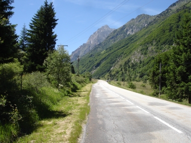

This climb is the ideal preparation for the real challenges. The road is quiet and nature beautiful, though one does not really get high (the pass lies at 1367 meters only). The road is situated in the narrow valley of the Torrent de la Lignarre and takes the cyclist through forests and villages. The climb can be divided into three sections. The first consists of a short warming up and two fairly steep kilometers (7-8%) with an upward but short (250 meters) deviation to 10%. In the middle part there are three rather easy kilometers (up to 6%). In the village of La Poutuire the final section of another five kilometers starts, which is again harder with a steepest kilometer of 8.2%. Towards the end climbing quickly becomes easier. In the last three kilometers the forests give way allowing more views of the high peaks around.
Rijd op 21 maart deze prachtige tocht vanuit Wageningen over de Veluwe. Keuze uit 80 en 125 km met resp. 580 en 990 hoogtemeters. Inschrijving vanaf 31 december
Tour for Life
Rijdt deze zomer de unieke en klassieke 8-daagse wielrentocht van Noord-Italië naar Zuid-Nederland voor Artsen zonder Grenzen!