
Windkapf-northwest
CyclingUp: Windkapf-northwest
Climbing effort: 424 cep
Elevation meters: 571
Steepest kilometer: 10.9%
Steepest 250 m: 14%
Foot: 359 m Top: 926 m
Mean slope: 6.1%
Length: 9.3 km
From: Hornberg
Road conditions (2018): average
Other race bikers: 0-1 per hour
Motor vehicles: 10-30 per hour
Scenery and road:
Restaurant or bar near top: no
PHOTOS Download gpx

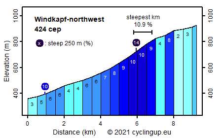
The most obvious route from Hornberg to Windkapf is the K5362 but because this road is wide and busy, and because a quiet alternative over Schwanenbach exists, cyclingup.eu chooses the last option. This climb and certainly the first six kilometers through the Schwanenbächletal are not really hard. In this first part, the gradient varies considerably but none of the 500 meter intervals slopes 10% or more. Always follow the signs to Windkapf except at a bifurcation just past the Schindeloch farm. At this point do not turn right towards Kucheloch but continue straight ahead. This is also the beginning of the steepest kilometer (10.8%) of the climb. Keep, a little bit further on, to the left and then turn right at a junction. By passing the Mooshof and cycling through a forest the K5362 is reached. Turn right at the junction. About 500 meters further on, turn right again towards Windkapf, a mountain with at its very top a settlement in decline.
Rijd op 21 maart deze prachtige tocht vanuit Wageningen over de Veluwe. Keuze uit 80 en 125 km met resp. 580 en 990 hoogtemeters. Inschrijving vanaf 31 december
Tour for Life
Rijdt deze zomer de unieke en klassieke 8-daagse wielrentocht van Noord-Italië naar Zuid-Nederland voor Artsen zonder Grenzen!