
Thurner-west
CyclingUp: Thurner-west
Climbing effort: 398 cep
Elevation meters: 515
Steepest kilometer: 10.3%
Steepest 250 m: 13%
Foot: 515 m Top: 1010 m
Mean slope: 5.9%
Length: 8.4 km
From: Wagensteig
Road conditions (2015): excellent
Other race bikers: 0-1 per hour
Motor vehicles: <10 per hour
Scenery and road:
Restaurant or bar near top: yes
PHOTOS Download gpx

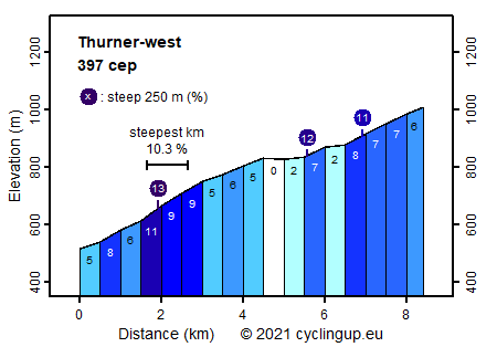
This is a scenic and varied climb via a narrow, almost perfect tarmac road with very little traffic. Much better does not exist. Too bad that the last two kilometers are less enjoyable. The ride begins in Wagensteig, first leads slightly uphill (5%) through a small valley, where the route then turns sharply to the left. Here it becomes steeper. The last part through the woods and the first parts in the open fields are the hardest with a kilometer of 10.3%. In addition, the slope varies considerably here, with a maximum of 13% for the steepest 250 meter section. After this steep section the road mostly continues on a ridge, gaining more and more height. This is the nicest part of the ascent with magnificent panoramic views and a landscape of fields, forests and farms. Again, the gradient varies considerably but it's never steep over longer distances. The final two kilometers on the main road are moderately steep (about 7%) and form a disappointing end.
Rijd op 22 maart deze prachtige tocht over de Veluwe, 75 of 125 kilometer vanuit Wageningen. Met veel hoogtemeters: resp. 550 en 970. Inschrijving
1K Ride
Rijd op 15 juni deze tocht met meer dan 1000 hoogtemeters; 80, 120 of 145 kilometer vanuit Oosterbeek. Inschrijving
Tour for Life
Rijdt deze zomer de unieke en klassieke 8-daagse wielrentocht van Noord-Italië naar Zuid-Nederland voor Artsen zonder Grenzen!